Clinton in Hunterdon County, New Jersey — The American Northeast (Mid-Atlantic)
Landsdown Trail
The Clinton Branch of the Lehigh Valley Railroad
The conductor was a local man by the name of Ahiaman "Hi" Wagner, whose career spanned the majority of the existence of the Branch.
Clinton thrived as an active cultural, tourist and industrial destination. Visitors were brought in from other locations across the state and from Pennsylvania and New York to see live entertainment such as musicals, plays, circuses and social events featured at the Clinton Music Hall. Silent, and later talking movies were shown as family fare. Guests would stay at the Clinton House Hotel or at other accommodations in town. For passengers in the train station, it was not uncommon to hear music playing while a pot-bellied stove heated the two separate waiting rooms, one for men and the other for women.
Joseph Williams was the station agent. In addition to selling tickets, he was the general information agent, freight agent, express agent and telegraph operator. Although there were only three short lengths of track, material such as coal, lumber, ice blocks, produce and even livestock, were transported by rail to and from Clinton. The local mill, built in 1810 along the bank of the South Branch of the Raritan River, became a lucrative business over the course of the next several decades, processing wool, grist, plaster, talc and graphite, as well as manufacturing of peach baskets.
Another business that prospered from the railroad was the nearby quarry with its 150' limestone cliff. Established in 1848 by three Irish immigrant brothers (Francis, Patrick and Terrence Mulligan), rock was removed from the cliff face by drilling and strategically placing and igniting blasting powder. The rock was then crushed into various sizes or burned in the limekilns and sold as fertilizer. This enterprise remained in the Mulligan family until the early 1960's.
Unlike Clinton, its counterpart, Landsdown, was never considered a town. Made up of parcels of farms collectively known as "Lansdowne", the area took its name from the estate of Charles Stewart, born in 1729. Stewart, who immigrated from Donegal, Ireland to the United States in 1750, acquired his farm in 1763. He resided there until a few years before his death in 1800. He was General George Washington's Commissionary General during the Revolutionary War and was a delegate to the Continental Congress in 1784 and 1785. The farm remained in the ownership of the family until 1924.
The passenger train station at Landsdown was on the busy Lehigh Valley Railroad main line and across from it was the Lehigh Valley Railroad's Pittstown Branch, which was 3.9 miles long. In comparison to the 10 daily trains on the Clinton Branch, The Pittstown Branch had only 4 daily trains. The Landsdown station was built slightly larger than the one in Clinton.
After passenger service ended in 1936 on the Clinton Branch, the stations at Landsdown and Clinton were demolished. In order to continue to accommodate freight trains, the wooden bridges over the Capoolong Creek and other waterways were replaced and upgraded with heavier steel girder bridges about a decade later.
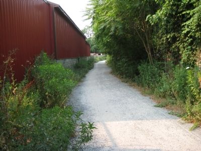
On April 1, 1976, the Consolidated Rail Corporation, known as Conrail, took over the Lehigh Valley Railroad and the Clinton Branch. In 1981, the freight traffic along the branch had dwindled to less than 12 freight cars a year. The surcharge imposed in 1982 was not enough to keep the Branch operating and it was abandoned. The tracks were removed several years later. In 1993, it was acquired by the county for the management of a recreation trail. It is now known as the Landsdown Trail. The structure standing before this sign id the Clinton Freight Station, the only remnant of the Branch's railroading era. The building, including the original hardwood floors and freight scale, have been restored and serves as offices for Cyrus Fox Lumber, Inc.
Erected by County of Hunterdon Parks and Recreation Department.
Topics. This historical marker is listed in these topic lists: Colonial Era • Industry & Commerce • Railroads & Streetcars • War, US Revolutionary. A significant historical month for this entry is April 1856.
Location. 40° 38.009′ N, 74° 54.77′ W. Marker is in Clinton, New Jersey, in Hunterdon County. Marker can be reached from W. Main Street, on the right when traveling east. Tle marker is located at the northen end of the trail, which begins at he back of Fox Lumber's parking lot. Touch for map. Marker is in this post office area: Clinton NJ 08809, United States of America. Touch for directions.
Other nearby markers. At least 8 other markers are within walking distance of this marker. Music Hall (about 300 feet away, measured in a direct line); Hunterdon Historical Museum (approx. 0.2 miles away); Red Mill Museum Village (approx. 0.2 miles away); The Quarry (approx. 0.2 miles away); The Mill (approx. 0.2 miles away); Hunterdon Museum Of Art (approx. 0.2 miles away); The Mulligans (approx. 0.2 miles away); Cornerstone, 1754 (approx. 0.2 miles away). Touch for a list and map of all markers in Clinton.
Related markers. Click here for a list of markers that are related to this marker. To better understand the relationship, study each marker in the order shown.
Credits. This page was last revised on June 16, 2016. It was originally submitted on July 8, 2010, by Alan Edelson of Union Twsp., New Jersey. This page has been viewed 1,550 times since then and 138 times this year. Photos: 1, 2, 3. submitted on July 8, 2010, by Alan Edelson of Union Twsp., New Jersey. • Bill Pfingsten was the editor who published this page.


