Jerome in Yavapai County, Arizona — The American Mountains (Southwest)
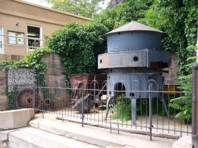
Jerome Blast Furnace
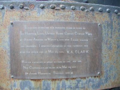
W.A. Clark
Maximum capacity of about 60 tons of ore per day. New Clarkdale plant blown in on May 28, 1915
Erected 1988 by Jerome Historical Society.
Topics. This historical marker is listed in these topic lists: Industry & Commerce • Natural Resources • Notable Places. A significant historical month for this entry is March 1929.
Location. 34° 45.039′ N, 112° 6.96′ W. Marker is in Jerome, Arizona, in Yavapai County. Marker is on Main Street, on the right when traveling east. Marker and furnace are located just west of the Jerome Town Hall. Touch for map. Marker is at or near this postal address: 303 Main Street, Jerome AZ 86331, United States of America. Touch for directions.
Other nearby markers. At least 8 other markers are within walking distance of this marker. Jerome Town Hall (a few steps from this marker); Jerome, Arizona (a few steps from this marker); Bartlett Hotel (a few steps from this marker); The Svob Family (a few steps from this marker); The Saloon (a few steps from this marker); Paul and Jerry's Saloon (within shouting distance of this marker); Mine Museum/Fashion Saloon (within shouting distance of this marker); Whitten Printers (within shouting distance of this marker). Touch for a list and map of all markers in Jerome.

Photographed By Bill Kirchner, July 7, 2010
3. Marker On Wall to the Left of the Jerome Blast Furnace
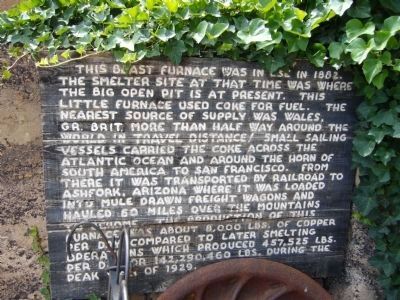
This blast furnace was in use in 1882. The smelter site at that time was where the big open pit is at present. This little furnace used coke for fuel. The nearest source of supply was Wales, GR. Brit. More than half way around the world in travel distance! Small sailing vessels carried the coke across the Atlantic Ocean and around the Horn of South America to San Francisco. From there it was transported by railroad to Ashfork, Arizona where it was loaded into mule drawn freight wagons and hauled 60 miles over the mountains to Jerome. The production of this furnace was about 8,000 lbs. of copper per day compared to later smelting operations which produced 457,525 lbs. per day or 142,290,460 lbs. during the peak year of 1929.
Credits. This page was last revised on June 16, 2016. It was originally submitted on July 17, 2010, by Bill Kirchner of Tucson, Arizona. This page has been viewed 1,521 times since then and 56 times this year. Photos: 1, 2, 3. submitted on July 17, 2010, by Bill Kirchner of Tucson, Arizona. • Syd Whittle was the editor who published this page.

