Solomons in Calvert County, Maryland — The American Northeast (Mid-Atlantic)
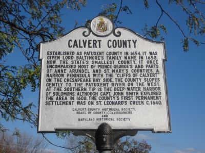
Calvert County
Erected by Calvert County Historical Society, Board of County Commissioners, Maryland Historical Society.
Topics. This historical marker is listed in these topic lists: Colonial Era • Settlements & Settlers. A significant historical year for this entry is 1654.
Location. 38° 19.87′ N, 76° 27.957′ W. Marker is in Solomons, Maryland, in Calvert County. Marker is at the intersection of Solomons Island Road (Maryland Route 2) and Lore Road, on the right when traveling south on Solomons Island Road. Marker is in the parking lot of the Visitor Center. Touch for map. Marker is in this post office area: Solomons MD 20688, United States of America. Touch for directions.
Other nearby markers. At least 8 other markers are within walking distance of this marker. Perils along the Patuxent (within shouting distance of this marker); Anchor (within shouting distance of this marker); a different marker also named Anchor (within shouting distance of this marker); Drum Point Lighthouse (about 400 feet away, measured in a direct line); Volunteer (about 400 feet away); The Ark of Hungerford Creek (about 500 feet away); Marine Railway Gears (about 500 feet away); Humphreys Rowing Skiff (about 600 feet away). Touch for a list and map of all markers in Solomons.
Regarding Calvert County. There is an identical marker at Visitor Center at the northern end of the county in Owings 100 feet north of the intersection of Southern Maryland Boulevard and Chaneyville Road.
Credits. This page was last revised on June 16, 2016. It was originally submitted on November 9, 2007, by F. Robby of Baltimore, Maryland. This page has been viewed 1,079 times since then and 10 times this year. Photos: 1, 2. submitted on November 9, 2007, by F. Robby of Baltimore, Maryland. • J. J. Prats was the editor who published this page.

