Lusby in Calvert County, Maryland — The American Northeast (Mid-Atlantic)
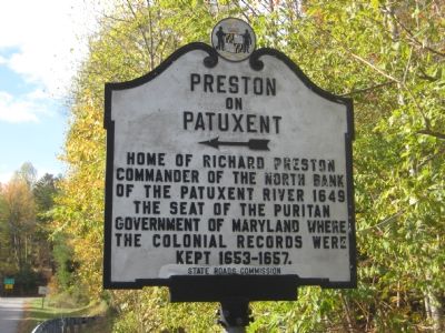
Preston on Patuxent
←
Home of Richard Preston, Commander of the North Bank of the Patuxent River 1649. Seat of the Puritan Government of Maryland where the colonial records were kept 1653–1657.
Erected by State Roads Commission.
Topics. This historical marker is listed in these topic lists: Colonial Era • Government & Politics. A significant historical year for this entry is 1649.
Location. 38° 24.951′ N, 76° 27.424′ W. Marker is in Lusby, Maryland, in Calvert County. Marker is at the intersection of Pardoe Road (Maryland Route 765) and Solomons Island Road (Maryland Route 2/4), on the right when traveling west on Pardoe Road. Marker is about 100 feet west of the intersection on Pardoe Road. Touch for map. Marker is at or near this postal address: 9248 Pardoe Road, Lusby MD 20657, United States of America. Touch for directions.
Other nearby markers. At least 8 other markers are within 3 miles of this marker, measured as the crow flies. Morgan Hill Farm (approx. 0.6 miles away); Middleham Chapel (approx. 1.6 miles away); The Cliffs of Calvert (approx. 1.8 miles away); Fate of the Flotilla (approx. 2.9 miles away); Weapons of War (approx. 3 miles away); Naval Warfare (approx. 3 miles away); The War of 1812 Living History (approx. 3 miles away); Jefferson Patterson Park & Museum (approx. 3 miles away). Touch for a list and map of all markers in Lusby.
Also see . . . Preston-on-the-Patuxent. Maryland Historical Trust entry (Submitted on November 10, 2007.)
Credits. This page was last revised on December 15, 2023. It was originally submitted on November 10, 2007, by F. Robby of Baltimore, Maryland. This page has been viewed 2,299 times since then and 91 times this year. Last updated on November 11, 2007, by F. Robby of Baltimore, Maryland. Photos: 1, 2. submitted on November 10, 2007, by F. Robby of Baltimore, Maryland.

