Independence in Jackson County, Missouri — The American Midwest (Upper Plains)
Our Jackson County Pioneers
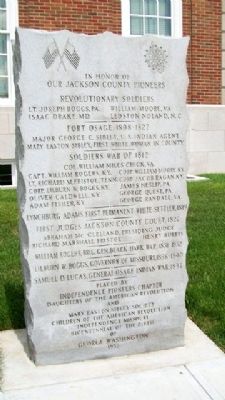
In Honor Of
Lt. Joseph Boggs, PA. • William Moore, VA.
Isaac Drake, MD. • Ledston Noland, N.C.
——————
Fort Osage, 1808-1827
Major George C. Sibley, U.S. Indian Agent
Mary Easton Sibley, First White Woman in County
——————
Soldiers War of 1812
Col. William Miles Chick, VA.
Capt. William Rogers, KY. • Corp. William Moore, KY.
Lt. Richard M. Fristoe, Tenn. • Corp. Jacob Ragan, KY.
Corp. Lilburn W. Boggs, KY. • James Heslip, PA.
Oliver Caldwell, KY. • George Quest, PA.
Adam Fisher, KY • George Randall, VA.
——————
Lynchburg Adams, First Permanent White Settler, 1819
——————
First Judges Jackson County Court, 1827
Abraham McClelland, Presiding Judge
Richard Marshall Fristoe • Henry Burris
——————
William Rogers, Brig. Gen. Black Hawk War, 1831-1832
——————
Lilburn W. Boggs, Governor of Missouri, 1836-1840
——————
Samuel D. Lucas, General, Osage Indian War, 1837
Bicentennial of the birth of
George Washington
Erected 1932 by Independence Pioneers Chapter, D.A.R., and Mary Easton Sibley Society, C.A.R.
Topics and series. This historical marker is listed in these topic lists: Forts and Castles • Government & Politics • Settlements & Settlers • War, US Revolutionary. In addition, it is included in the Daughters of the American Revolution series list. A significant historical year for this entry is 1812.
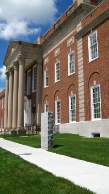
Location. 39° 5.538′ N, 94° 24.97′ W. Marker is in Independence, Missouri, in Jackson County. Marker is on Lexington Avenue near Main Street, on the right when traveling west. Marker is on the south grounds of the former county courthouse. Touch for map. Marker is at or near this postal address: 112 West Lexington Avenue, Independence MO 64050, United States of America. Touch for directions.
Other nearby markers. At least 8 other markers are within walking distance of this marker. A Century of Progress (within shouting distance of this marker); Harry S. Truman (within shouting distance of this marker); Historic Courthouse (within shouting distance of this marker); First Battle of Independence (within shouting distance of this marker); Harpie Club (within shouting distance of this marker); Santa Fe Trail (within shouting distance of this marker); Here the Oregon Trail Began
(within shouting distance of this marker); Jackson County Courthouse (within shouting distance of this marker). Touch for a list and map of all markers in Independence.
Credits. This page was last revised on December 16, 2020. It was originally submitted on August 24, 2010, by William Fischer, Jr. of Scranton, Pennsylvania. This page has been viewed 1,476 times since then and 21 times this year. Photos: 1, 2. submitted on August 24, 2010, by William Fischer, Jr. of Scranton, Pennsylvania.

