Pineville in Rapides Parish, Louisiana — The American South (West South Central)
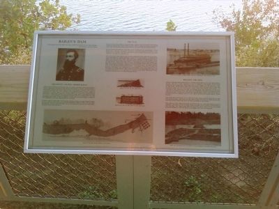
Bailey's Dam
"If damming would get the fleet off, it would have been afloat long before." Rear Admiral David D. Porter
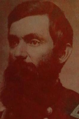
Lieutenant Colonel Joseph Bailey
While Union officers surveyed the situation and discussed the possible loss of the boats trapped in the river, Lieutenant Colonel Joseph Bailey, a West Point graduate with the Fourth Wisconsin Cavalry and Acting Engineer of the 19th Army Corps, came forward with a plan. Born in Ashtabula County, Ohio, in 1827, Bailey grew up in Illinois and moved to Wisconsin. There he learned to construct dams, mills, and bridges using practical engineering techniques perfected by lumbermen on the Wisconsin frontier. at the outbreak of the Civil War, he raised a company of lumbermen and was commissioned a captain.
Bailey's skills were first notices by General Banks at Port Hudson when Bailey constructed wing dams across Thompson Creek to free two trapped steamers. Banks assigned him as an engineer to one of his officers, General William B. Franklin.
The Plan
Bailey's plan was simple - build several short dams extending from both banks of the river at the lower rapids. When completed, the dams would raise the water level seven feet, enough to float Porter's boats across.
Bailey presented his plan to the Union command and engineers. It was rejected. General Franklin, himself a distinguished engineer, came forward to support the plan and eventually Porter and Banks accepted the idea. On April 29, work began.
The dams, built just above the lower rapids near the town of Alexandria (near the present Rapides Regional Medical Center complex), consisted of three sections 760 feet long. The first was a tree dam which made use of the large stands of pine, oak, and elm trees available on the Pineville side of the river. From this side, this dam extended about two-thirds the distance across the river. The second dam, extending from the Alexandria side, consisted of wooden cribs filled with stone, iron, and brick debris collected from destroyed buildings. A central dam, built in the gap between the first two, consisted of four sunken navy coal barges filled with bricks and iron rails. This central dam would be rammed by the lead gunboat or blown up to provide an opening allowing the fleet to be carried over the falls by the released water.
Building the dam
Nearly 3,000 men from 24 regiments, supported by 200 wagons and 1000 horses, mules, and oxen, were ordered to begin work on the dams. Units with experiences lumbermen were selected to cut trees on the Pineville side of the river. Among them were the 29th Maine, 110th and 161st New York, the Pioneer Corps of the 13th Army Corps, and units from Wisconsin. To construct the crib dams on the Alexandria side, the soldiers of the 97th and 99th Colored Infantry, regiments composed mostly of freed slaves, were selected. Work was conducted around-the-clock in six hour shifts. Pineville soon looked as if it had "been mowed by some great giant reaper."
The tree dam was built of layers of logs that sloped upward on the downstream side. The ends of the trees were trimmed of their branches, and the entire structure was covered with brick and stone.
The cribs in the crib dam were constructed of a framework of heavy timbers. The ends of the timbers were notched to fit tightly together at the corners. The cribs were then filled with brick, iron, stone and other building debris collected from Alexandria and the countryside.
Topics. This historical marker is listed in this topic list: War, US Civil. A significant historical date for this entry is April 29, 1827.
Location. 31° 19.265′ N, 92° 26.973′ W. Marker is in Pineville, Louisiana, in Rapides Parish. Marker is on Riverfront Street west of Main Street, on the left when traveling west. Marker pavilion is located at the Forts Randolph and Buhlow State Historic Site, on the left after you go through the entrance gates. Touch for map. Marker is at or near this postal address: 135 Riverfront Street, Pineville LA 71360, United States of America. Touch for directions.
Other nearby markers. At least 8 other markers are within walking distance of this marker. The Red River Campaign (here, next to this marker); The Dam Works (here, next to this marker); Who was Stationed at Fort Randolph (approx. 0.2 miles away); Why was Fort Randolph Built? (approx. ¼ mile away); How was Fort Randolph Built? (approx. ¼ mile away); Desertion and the end of the War (approx. 0.3 miles away); Deserting soldiers and the end of the war (approx. 0.4 miles away); Who was Fort Buhlow named after? (approx. 0.4 miles away). Touch for a list and map of all markers in Pineville.
Related markers. Click here for a list of markers that are related to this marker. To better understand the relationship, study each marker in the order shown.
Also see . . .
1. Joseph Bailey (General). Wikipedia entry (Submitted on November 29, 2010, by Lee Hattabaugh of Capshaw, Alabama.)
2. Bailey's Dam. American Battlefields Trust website entry (Submitted on November 29, 2010, by Lee Hattabaugh of Capshaw, Alabama.)
Credits. This page was last revised on April 26, 2021. It was originally submitted on November 29, 2010, by Lee Hattabaugh of Capshaw, Alabama. This page has been viewed 1,289 times since then and 24 times this year. Photos: 1, 2, 3. submitted on November 29, 2010, by Lee Hattabaugh of Capshaw, Alabama. • Craig Swain was the editor who published this page.
Editor’s want-list for this marker. A clear and readable close-up photo of the marker. • Can you help?


