Near Clarksville in Mecklenburg County, Virginia — The American South (Mid-Atlantic)
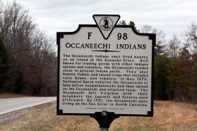
Occaneechi Indians
Erected 2000 by Department of Historic Resources. (Marker Number F-98.)
Topics and series. This historical marker is listed in this topic list: Native Americans. In addition, it is included in the Virginia Department of Historic Resources (DHR) series list. A significant historical month for this entry is May 1676.
Location. 36° 32.697′ N, 78° 32.381′ W. Marker is near Clarksville, Virginia, in Mecklenburg County. Marker is on U.S. 15 just north of the North Carolina State Line, on the right when traveling north. Touch for map. Marker is in this post office area: Clarksville VA 23927, United States of America. Touch for directions.
Other nearby markers. At least 8 other markers are within 7 miles of this marker, measured as the crow flies. Tungsten Queen (approx. 3.7 miles away in North Carolina); Trading Path (approx. 3.7 miles away in North Carolina); Sunnyside School ca. 1870-1908 (approx. 5 miles away); Henry Pattillo (approx. 5.4 miles away in North Carolina); Mecklenburg County Veterans Memorial (approx. 5½ miles away); John Lederer (approx. 6.1 miles away in North Carolina); a different marker also named Occaneechi Indians (approx. 6.3 miles away); John Penn (approx. 7 miles away in North Carolina). Touch for a list and map of all markers in Clarksville.
Also see . . . Occaneechi Indian Tribe History. “They then dwelt on the middle and largest island in Roanoke river, just below the confluence of the Staunton and the Dan, near the site of Clarksville, Mecklenburg county, Va. Their fields were on the north bank of the river, where they raised large crops of corn, having always on hand as a reserve a year’s supply.” (Submitted on March 9, 2011.)
Credits. This page was last revised on June 16, 2016. It was originally submitted on March 9, 2011, by J. J. Prats of Powell, Ohio. This page has been viewed 1,105 times since then and 38 times this year. Photos: 1, 2. submitted on March 9, 2011, by J. J. Prats of Powell, Ohio.

