Bedford in Bedford County, Virginia — The American South (Mid-Atlantic)
Bedford
Hunter’s Raid
— 1864 Valley Campaign —
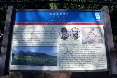
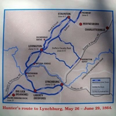
On the evening of June 15, 1864, the lead element of Union Gen. David Hunter’s 18,000-man army arrived here and cam near Avenel. The main force arrived the following morning and started destroying the Virginia and Tennessee Railroad tracks, burning the depot and businesses before moving on toward Lynchburg. Hunter had taken command in the Shenandoah Valley on May 19, with orders to destroy railroad facilities and supplies in Staunton and Lynchburg, then either return to lower Valley or join Gen. Ulysses S. Grant near Petersburg.
Learning of Hunter’s plans, on June 12, Confederate Gen. Robert E. Lee assigned Gen. Jubal A. Early the command of a diversionary corps from the Army of Northern Virginia to defeat Hunter. Later, if feasible, Early was to slice down the Valley, cross the Potomac River and threaten Washington. Lee hoped to induce Grant to detach troops from eastern Virginia and relieve the strain on Lee’s defense of Richmond.
Hunter attacked Lynchburg on June 18, but Early had arrived in the nick of time. After his probes were repulsed, Hunter retreated the next day along the same route taken on his advance, with Early’s 8,000-man force in pursuit. Early’s advance caught up with Hunter just east of town and carried the fight to downtown Liberty. The Federals retreated west to positions just outside town, and darkness ended the fighting. Early planned to resume the attack the next morning, but Hunter pulled out during the night. Early set off in pursuit, out of Bedford County toward Salem and Hanging Rock.
Erected by Virginia Civil War Trails.
Topics and series. This historical marker is listed in these topic lists: Railroads & Streetcars • War, US Civil. In addition, it is included in the Virginia Civil War Trails series list. A significant historical year for this entry is 1864.
Location. 37° 20.061′ N, 79° 31.426′ W. Marker is in Bedford, Virginia, in Bedford County. Marker is at the intersection of South Bridge Street and West Main Street (U.S. 221), on the left when traveling north on South Bridge Street. Touch for map. Marker is in this post office area: Bedford VA 24523, United States of America. Touch for directions.
Other nearby markers. At least 8 other markers are within walking distance of this marker. Bedford County WWII Memorial (about 300 feet away, measured in a direct line); Bedford County Confederate Monument (about 300 feet away); a different marker also named Bedford (about 500 feet away); Bedford’s Volunteer Company (about 500 feet away); Avenel (approx. ¼ mile away); Peaks of Otter Road (approx. 0.3 miles away); Randolph-Macon Academy (approx. 0.6 miles away); Four Chaplains Field Chapel (approx. 0.7 miles away). Touch for a list and map of all markers in Bedford.
More about this marker. On the upper right are portraits of "Gen. David Hunter" and "Gen. Jubal Early" and a map of Hunter's route.
On the lower left is a water color with the caption, "The Peaks of Otter and the Town of Liberty (now Bedford City) was painted in 1855 by Ed Byer. - Courtesy of the Virginia Historical Society's Lora Robins Collection, partial gift of Mildred E. Lang".
Also see . . . Hunter's Raid (or the Lynchville Campaign). John's Military history website entry (Submitted on March 26, 2022, by Larry Gertner of New York, New York.)
Credits. This page was last revised on March 26, 2022. It was originally submitted on April 3, 2011, by Bernard Fisher of Richmond, Virginia. This page has been viewed 1,381 times since then and 47 times this year. Photos: 1, 2, 3, 4. submitted on April 3, 2011, by Bernard Fisher of Richmond, Virginia.


