Shiloh in Hardin County, Tennessee — The American South (East South Central)
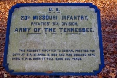
23rd Missouri Infantry
Prentiss' Divsion
— Army of the Tennessee —
U.S.
23d Missouri Infantry,
Prentiss' (6th) Division,
Army of the Tennessee
Erected by Shiloh National Military Park Commission. (Marker Number 231.)
Topics. This historical marker is listed in this topic list: War, US Civil. A significant historical month for this entry is April 1869.
Location. 35° 8.047′ N, 88° 20.215′ W. Marker is in Shiloh, Tennessee, in Hardin County. Marker is on Sunken Road, 0.2 miles east of Eastern Corinth Road, on the left. Touch for map. Marker is in this post office area: Shiloh TN 38376, United States of America. Touch for directions.
Other nearby markers. At least 8 other markers are within walking distance of this marker. 18th Wisconsin Infantry (within shouting distance of this marker); 18th Missouri Infantry (within shouting distance of this marker); 12th Michigan Infantry (within shouting distance of this marker); Ohio 5th Battery Light Artillery (within shouting distance of this marker); 8th Iowa Infantry (about 300 feet away, measured in a direct line); 31st Indiana Infantry (about 400 feet away); Shaver's Brigade (about 400 feet away); 21st Missouri Infantry (about 400 feet away). Touch for a list and map of all markers in Shiloh.
Click on the ad for more information.
Please report objectionable advertising to the Editor.
sectionhead>More about this marker. Marker is in the "Hornets' Nest" section of the Sunken Road, in Shiloh National Military Park. The road is an unpaved pedestrian route.Please report objectionable advertising to the Editor.
Related markers. Click here for a list of markers that are related to this marker. To follow the movements of the 23rd Missouri Infantry at Shiloh, study the markers in the order shown. .
Credits. This page was last revised on June 16, 2016. It was originally submitted on November 22, 2010, by Allen Gathman of Pocahontas, Missouri. This page has been viewed 649 times since then and 15 times this year. Last updated on June 8, 2011, by Allen Gathman of Pocahontas, Missouri. Photos: 1, 2. submitted on November 22, 2010, by Allen Gathman of Pocahontas, Missouri. • Craig Swain was the editor who published this page.

