Cottonwood Falls in Chase County, Kansas — The American Midwest (Upper Plains)
Bates Grove and the Area Adjacent to the Cottonwood River Dam
Inscription.
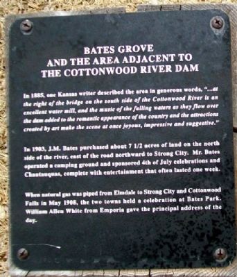
In 1885, one Kansas writer described the area in generous words, "...at the right of the bridge on the south side of the Cottonwood River is an excellent water mill, and the music of the falling waters as they flow over the dam added to the romantic appearance of the country and the attractions created by art make the scene at once joyous, impressive and suggestive."
In 1903, J.M. Bates purchased about 7 1/2 acres of land on the north side of the river, east of the road northward to Strong City. Mr. Bates operated a camping ground and sponsored 4th of July celebrations and Chautauquas, complete with entertainment that often lasted one week.
When natural gas was piped from Elmdale to Strong City and Cottonwood Falls in May 1908, the two towns held a celebration at Bates Park. William Allen White from Emporia gave the principal address of the day.
Topics. This historical marker is listed in these topic lists: Entertainment • Settlements & Settlers • Waterways & Vessels. A significant historical month for this entry is May 1908.
Location. 38° 22.515′ N, 96° 32.466′ W. Marker is in Cottonwood Falls, Kansas, in Chase County. Marker is at the north end of the Cottonwood River Bridge, about 400 feet northeast of the intersection of Broadway and Mill Street. Touch for map. Marker is in this post office area: Cottonwood Falls KS 66845, United States of America. Touch for directions.
Other nearby markers. At least 8 other markers are within walking distance of this marker. Chase County and the City of Cottonwood Falls (here, next to this marker); Cottonwood River Bridges at Cottonwood Falls (here, next to this marker); Cottonwood River Dam (here, next to this marker); Connecting the Chase County Community (about 400 feet away, measured in a direct line); Oldest Operating Courthouse in Kansas (approx. 0.3 miles away); Chase County War Memorial (approx. 0.3 miles away); A Landmark of Distinction (approx. 0.3 miles away); Chase County All Veterans Memorial (approx. 0.6 miles away). Touch for a list and map of all markers in Cottonwood Falls.
Credits. This page was last revised on December 7, 2021. It was originally submitted on August 5, 2011, by William Fischer, Jr. of Scranton, Pennsylvania. This page has been viewed 492 times since then and 14 times this year. Photos: 1, 2. submitted on August 6, 2011, by William Fischer, Jr. of Scranton, Pennsylvania.

