Chilhowie in Smyth County, Virginia — The American South (Mid-Atlantic)
Chilhowie
Stoneman at Greever’s Switch
— Stoneman Raid —
Sidebar. On December 1, 1864, Union Gen. George Stoneman led 5,700 cavalrymen east from Knoxville, Tennessee, to destroy iron-, lead-, and saltworks in Virginia that were essential to the Confederate war effort. After actions at Kingsport and Bristol, Stoneman struck at Marion, Wytheville, and Austinville, then destroyed the saltworks at Saltville. Stoneman returned to Tennessee on January 1, 1865, having laid waste to every factory, railroad, depot, and warehouse in his path.
Sidebar. Fountain Beattie (Nov. 10, 1840–Mar. 25, 1923), born at the Town House, enlisted in the 1st Va. Cavalry at Abingdon, Va., where he met John S. Mosby. Beattie later became one of Mosby’s fifteen original Partisan Rangers and Mosby’s closest confidant.
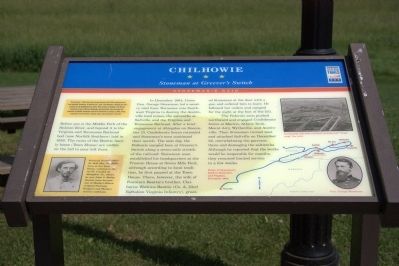
Before you is the Middle Fork of the Holston River, and beyond it is the Virginia and Tennessee Railroad bed (now Norfolk Southern) laid in 1856. The ruins of the Beattie family home (Town House) are visible on the hill to your left front.
In December 1864, Union Gen. George Stoneman led a cavalry raid from Tennessee into southwest Virginia to destroy the Austinvine lead mines, the saltworks at Saltville, and the Virginia and Tennessee Railroad. After a brief engagement at Abingdon on December 13, Confederate forces retreated and Stoneman's men continued their march. The next day, the Federals camped here at Greever’s Switch along a seven-mile stretch of the railroad. Stoneman soon established his headquarters at the Preston House at Seven Mile Ford, although according to local tradition, he first paused at the Town House. There, however, the wife of Fountain Beattie’s brother, Claiborne Watkins Beattie (Co. A, 23rd Battalion Virginia Infantry), greet- ed Stoneman at the door with a gun and ordered him to leave. He followed her orders and camped for the night at the foot of the hill.
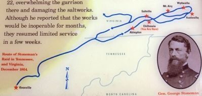
The Federals soon pushed northward and engaged Confederate forces at Marion, Atkins Tank, Mount Airy, Wytheville, and Austinville. Then Stoneman turned west and attacked Saltville on December 22, overwhelming the garrison there and damaging the saltworks. Although he reported that the works would be inoperable for months, they resumed limited service in a few weeks.
Erected by Civil War Trails.
Topics. This historical marker is listed in this topic list: War, US Civil. A significant historical month for this entry is January 1851.
Location. 36° 47.72′ N, 81° 40.902′ W. Marker is in Chilhowie, Virginia, in Smyth County. Marker is at the intersection of Whitetop Road (Virginia Route 107) and Exit 35 (Interstate 81), on the left when traveling
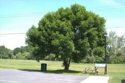
north on Whitetop Road. It is at the H.L. Bonham Regional Development & Tourism Center parking lot, on the northwest corner of the exit. Touch for map. Marker is at or near this postal address: 405 Whitetop Rd, Chilhowie VA 24319, United States of America. Touch for directions.
Other nearby markers. At least 8 other markers are within 3 miles of this marker, measured as the crow flies. Transportation Through the Ages (within shouting distance of this marker); a different marker also named Chilhowie (approx. 0.2 miles away); Farthest West, 1750 (approx. 0.2 miles away); Town House (approx. 0.2 miles away); Chilhowie Methodist Episcopal Church (approx. half a mile away); Sulphur Springs Church and Campground (approx. 0.9 miles away); Smyth County / Washington County (approx. 1.1 miles away); William Campbell’s Grave (approx. 2.4 miles away). Touch for a list and map of all markers in Chilhowie.
More about this marker. On the right side of the marker there is a map captioned “route of Stoneman’s Raid in Tennessee and Virginia, December 1864” flanked top and bottom by two photographs. On top “destroying railroads included heating and ‘wrapping’ the rails.” Below is a portrait of General George Stoneman. On the lower left of the marker is a portrait of Fountain Beattie.
Also see . . . Fountain Claibourne (Beatie) Beattie (1840 - 1923). WikiTree website entry (Submitted on February 18, 2022, by Larry Gertner of New York, New York.)
Credits. This page was last revised on April 11, 2022. It was originally submitted on August 11, 2011, by J. J. Prats of Powell, Ohio. This page has been viewed 1,235 times since then and 42 times this year. Photos: 1, 2, 3. submitted on August 11, 2011, by J. J. Prats of Powell, Ohio.


