Carrington Avenue
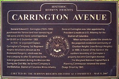
In 1846, he organized Captain Carrington’s Company, 1st Regiment Virginia Volunteers (known as the Richmond Rangers), which was the first company to offer its services to the federal government during the Mexican War. During the Civil War, he formed Company A, 2nd Battalion, District of Columbia Military Infantry. General Carrington was later appointed by President Lincoln as U.S. Attorney of the District of Columbia.
When surveyors platted the streets for the projected residential community of Charlton Heights (now Berwyn Heights) in 1888, in honor of the General, the northern boundary of Carrington’s property became Carrington Avenue.
The Maryland National Capital Park & Planning Commission renamed the street Osage Street by 1941.
Erected 2007 by Berwyn Heights Historical Committee.
Topics and series. This historical marker is listed in these topic lists: Settlements & Settlers • War, Mexican-American • War, US Civil. In addition, it is included in the Former U.S. Presidents: #16 Abraham Lincoln series list. A significant historical date for this entry is September 9, 1869.
Location. 38° 59.368′
Other nearby markers. At least 8 other markers are within walking distance of this marker. Town of Berwyn Heights (about 500 feet away, measured in a direct line); La Belle Avenue (approx. 0.2 miles away); Edmonston Road (approx. 0.2 miles away); Schools of Berwyn Heights (approx. 0.2 miles away); Charlton Avenue (approx. ¼ mile away); Berwyn Heights Association (approx. 0.4 miles away); Washington Spa Spring & Gretta Railroad (approx. half a mile away); The Berwyn Heights Company (approx. half a mile away). Touch for a list and map of all markers in Berwyn Heights.
More about this marker. This is one in a series of markers erected by the Berwyn Heights Historical Committee. The markers commemorate the historic street names of the Town of Berwyn Heights, which were frequently named after notable people.
Regarding Carrington Avenue. The home in which General Carrington lived, located at 5933 Natasha Drive, is also the oldest house in Berwyn Heights, dating back to circa 1790.
Credits. This page was last revised on November 22, 2019. It was originally submitted on December 11, 2011, by Kerstin Harper of Berwyn Heights, Maryland. This page has been viewed 576 times since then and 16 times this year. Photos: 1, 2. submitted on December 11, 2011, by Kerstin Harper of Berwyn Heights, Maryland. • Bill Pfingsten was the editor who published this page.

