Crystal Springs in Copiah County, Mississippi — The American South (East South Central)
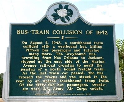
Bus-Train Collision of 1942
Erected 2008 by Mississippi Department of Archives and History.
Topics and series. This historical marker is listed in these topic lists: Railroads & Streetcars • Roads & Vehicles • War, World II. In addition, it is included in the Mississippi State Historical Marker Program series list. A significant historical year for this entry is 1942.
Location. 31° 59.208′ N, 90° 21.53′ W. Marker is in Crystal Springs, Mississippi, in Copiah County. Marker is at the intersection of West Railroad Avenue and West Marion Avenue, on the right when traveling south on West Railroad Avenue. Touch for map. Marker is in this post office area: Crystal Springs MS 39059, United States of America. Touch for directions.
Other nearby markers. At least 8 other markers are within 9 miles of this marker, measured as the crow flies. Tommy Johnson (about 300 feet away, measured in a direct line); Crystal Springs (about 400 feet away); Chautauqua Buildings (approx. 0.9 miles away); P.T.A. Birthplace (approx. 0.9 miles away); Chautauqua Tabernacle (approx. 0.9 miles away); Spring House (approx. one mile away); Terry (approx. 8.4 miles away); Robert Johnson (approx. 8.9 miles away). Touch for a list and map of all markers in Crystal Springs.
Credits. This page was last revised on November 5, 2022. It was originally submitted on December 25, 2011, by Jeff Lovorn of Florence, Mississippi. This page has been viewed 797 times since then and 23 times this year. Photo 1. submitted on December 25, 2011, by Jeff Lovorn of Florence, Mississippi. • Craig Swain was the editor who published this page.
Editor’s want-list for this marker. A wide shot of the marker and its surroundings. • Can you help?
