Chloride in Mohave County, Arizona — The American Mountains (Southwest)
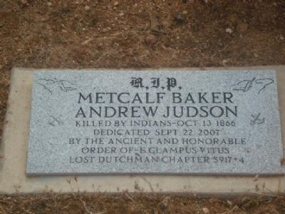
Metcalf Baker - Andrew Judson
Killed by Indians Oct. 13th 1866
Erected 2007 by E Clampus Vitus Lost Dutchman Chapter 5917+4.
Topics and series. This historical marker is listed in this topic list: Cemeteries & Burial Sites. In addition, it is included in the E Clampus Vitus series list. A significant historical year for this entry is 1866.
Location. 35° 24.666′ N, 114° 12.377′ W. Marker is in Chloride, Arizona, in Mohave County. Marker can be reached from Magnolia Street, on the right when traveling south. Touch for map. Marker is in this post office area: Chloride AZ 86431, United States of America. Touch for directions.
Other nearby markers. At least 5 other markers are within 10 miles of this marker, measured as the crow flies. Chloride (approx. 0.4 miles away); Arizona and Utah / Western Arizona Railway (approx. half a mile away); a different marker also named Chloride (approx. 3.1 miles away); Mineral Park (approx. 6.1 miles away); Cerbat (approx. 9.2 miles away).
More about this marker. The marker is located just past the Chloride Cemetery. It is known as the Chloride Grave. Four people are buried within a fence with two separate markers, plus there may be other unknown graves outside the enclosure.
Also see . . . Arizona Pioneer & Cemetery Research Project. A post by Kathy Block with information and history of Chloride, photos and additional information regarding Metcalf Baker and Andrew Judson. (Submitted on October 31, 2011.)
Credits. This page was last revised on June 16, 2016. It was originally submitted on October 28, 2011, by Frank Houdek of Kingman, Arizona. This page has been viewed 1,802 times since then and 65 times this year. Last updated on February 8, 2012, by Michael Kindig of Elk Grove, California. Photo 1. submitted on October 28, 2011, by Frank Houdek of Kingman, Arizona. • Syd Whittle was the editor who published this page.
Editor’s want-list for this marker. Wide area view of marker and its surroundings. • • Can you help?
