Memphis in Shelby County, Tennessee — The American South (East South Central)
Spain
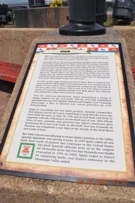
Hernando DeSoto's pioneering expedition stumbled on the Mississippi somewhere south of here on May 8, 1541, but it is unlikely that they raised a Spanish banner over their discovery. After a laborious two year trek up from Florida and a recent defeat by the Chickasaws, DeSoto's force was in tatters. He was searching for seven mythical cities of gold, and the river was more of an obstacle to him than a discovery. DeSoto died a year later on the bank of the river he had found, and was buried beneath its waters. The remnants of his expedition made a hasty exit down river to the Gulf. No Spaniard set foot on the Mississippi for the next 150 years.
In 1762, on the verge of losing the Seven Years' War to England, the French sold the Mississippi's west bank and the New Orleans area to Spain. At war's end in 1763, England took control of the land east of the river above New Orleans, only to lose it in 1779 when Governor Galves of Louisiana captured British Fort Bute above New Orleans and claimed the entire lower river for Spain.
After the American Revolution, Spain maintained a string of ragtag outposts on the west bank, and by 1791 had established east bank forts near New Madrid, Missouri and Nogales, now Vicksburg, Mississippi. A fleet of Spanish war vessels patrolled the river between them.
Eager to consolidate his east bank position, Spanish commander Don Manuel Gayoso de Lemos established a camp directly across the river from this spot on May 20, 1795 and ferried back and forth to negotiate with the Chickasaw on the bluff east of you. After liberal doses of rum, presents, and promises the Native Americans gave permission for a fort to be built on the bluff. Fort San Fernando de Barracas was completed a year later at the mouth of the Wolf River just north of here.
But while Gayoso was laboring to secure Spain's position in the Valley, Spanish diplomats were giving it away. In 1795, Spain ceded all east bank land north of present day Louisiana to the United States. Die-hard Spanish officials held on to the outpost for 18 months more, but Fort San Fernando was finally evacuated in 1797. In 1800, Spain ceded to France its remaining lands, and Spain's influence in the Mississippi Valley ended.
Erected by Mud Island River Park.
Topics. This historical marker is listed in these topic lists: Exploration • Forts and Castles • Native Americans • Settlements & Settlers. A significant historical month for this entry is May 1673.
Location.
35° 8.656′ N, 90° 3.569′ W. Marker is in Memphis, Tennessee, in Shelby County. Marker can be reached from Island Drive, one mile south of A.W. Willis Avenue. Marker is at the south end of Mud Island under the Spanish flag. Touch for map. Marker is at or near this postal address: 125 North Front Street, Memphis TN 38103, United States of America. Touch for directions.
Other nearby markers. At least 8 other markers are within walking distance of this marker. Confederate States of America (here, next to this marker); Tennessee (a few steps from this marker); North Carolina (a few steps from this marker); Great Britain (a few steps from this marker); France (a few steps from this marker); Memphis Queen II (approx. 0.2 miles away); Cobblestones (approx. 0.2 miles away); Civil War Hospital (approx. ¼ mile away). Touch for a list and map of all markers in Memphis.
Also see . . . Mud Island River Park. (Submitted on March 20, 2012, by Bernard Fisher of Richmond, Virginia.)
Credits. This page was last revised on June 16, 2016. It was originally submitted on March 20, 2012, by Sandra Hughes Tidwell of Killen, Alabama, USA. This page has been viewed 594 times since then and 13 times this year. Photos: 1, 2. submitted on March 20, 2012, by Sandra Hughes Tidwell of Killen, Alabama, USA. • Bernard Fisher was the editor who published this page.

