Near Pocahontas in Hardeman County, Tennessee — The American South (East South Central)
Hell on the Hatchie
Engagement at Davis Bridge
— October 5, 1862 —
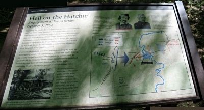
Eventually, the Federals seized the heights dominating the bend, but there fighting ceased. The Confederates, content with simply delaying the enemy, escaped south into Mississippi along another road. As darkness fell the exhausted Union troops tended to the wounded and buried the dead from one more bitter military action in the continuing bloody campaign for control of the Mississippi Valley.
At bottom left is a photograph of a bridge captioned Woodbury Bridge across the Chickahominy appears here much as Davis Bridge would have looked in October of 1852.
At top right are photographs of the opposing commanders. The caption for General Van Dorn reads: The commander of the Confederate forces, General Earl Van Dorn, was headstrong and impulsive. Troops under his leadership incurred serious defeats at both Pea Ridge and Corinth. Better suited to cavalry tactics, he conducted the daring raid on the Union supply depot at Holly Springs in December 1862, which helped thwart General U.S. Grant's first attempt to capture Vicksburg. The caption for General Ord reads: General E.O.C. Ord, commander of the Union troops, was wounded at Davis Bridge and referred to it as "the miserable bridge." After recovering from his wounds, Ord returned to active duty during the Siege of Vicksburg. He served under General U.S. Grant through the remainder of the War and in 1865 commanded the Army of the James, directing it with great skill at both Petersburg and Appomattox.
At bottom right a map shows troop movements during the battle.
Erected by National Park Service - Shiloh National Military Park.
Topics and series. This historical marker is listed in this topic list: War, US Civil. In addition, it is included in the Former U.S. Presidents: #18 Ulysses S. Grant series list. A significant historical month for this entry is October 1852.
Location. 35° 1.7′ N, 88° 47.701′ W. Marker is near Pocahontas, Tennessee, in Hardeman County. Marker can be reached from Essary Springs Road, 1.3 miles south of Wolf Pen Road, on the right when traveling north. The marker is at the bank of the Hatchie River at the present
(2012) end of a trail which starts at Essary Springs Road. The marker is a 1500 foot walk from the road. A related NPS marker is located at the trailhead and parking area at the road. Touch for map. Marker is in this post office area: Pocahontas TN 38061, United States of America. Touch for directions.
Other nearby markers. At least 8 other markers are within 15 miles of this marker, measured as the crow flies. Battle of Davis Bridge (about 700 feet away, measured in a direct line); Engagement at Davis Bridge (approx. 0.3 miles away); a different marker also named Battle of Davis Bridge (approx. 1.6 miles away); Battle of Tuscumbia (approx. 3.6 miles away); Battle Of Chewalla (approx. 8.4 miles away); Veteran's Plaza (approx. 10.7 miles away); Kossuth (approx. 13.8 miles away in Mississippi); In affectionate memory of the early settlers of McNairy County and the Town of Purdy (approx. 15.1 miles away). Touch for a list and map of all markers in Pocahontas.
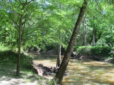
Regarding Hell on the Hatchie. The trail to the marker follows the Civil War-era route of State Line Road and ends at the Hatchie River. Property has been acquired as park land on the east bank where most of the battle occurred. A footbridge across the river and additional signage is planned.
Related marker. Click here for another marker that is related to this marker. To better understand the relationship, study each marker in the order shown.
Credits. This page was last revised on June 16, 2016. It was originally submitted on June 8, 2012, by David Graff of Halifax, Nova Scotia. This page has been viewed 1,131 times since then and 58 times this year. Photos: 1, 2, 3. submitted on June 8, 2012, by David Graff of Halifax, Nova Scotia. • Craig Swain was the editor who published this page.


