Near Sharpsburg in Washington County, Maryland — The American Northeast (Mid-Atlantic)
Jackson's Command
Lawton's Brigade, Ewell's Division
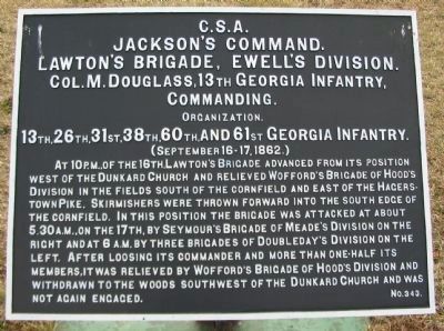
Jackson's Command.
Lawton's Brigade, Ewell's Division.
Col. M. Dougass, 13th Georgia Infantry,
Commanding.
Organization.
13th, 26th, 31st, 38th, 60th, and 61st Georgia Infantry.
(September 16-17, 1862.)
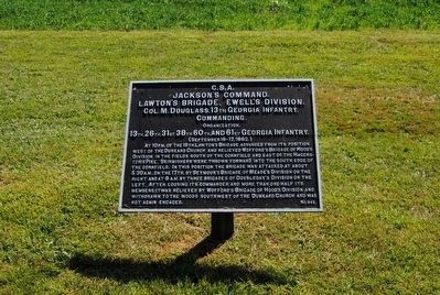
At 10 p.m., of the 16th, Lawton's Brigade advanced from its position west of the Dunkard Church and relieved Wofford's Brigade of Hood's Division in the fields south of the cornfield and east of the Hagerstown Pike. Skirmishers were thrown forward into the south edge of the cornfield. In this position the brigade was attacked at about 5:30 a.m., on the 17th, by Seymour's Brigade of Meade's Division on the right and at 6 a.m. by three brigades of Doubleday's Division on the left. After loosing its commander and more than one-half its members, it was relieved by Wofford's Brigade of Hood's Division and withdrawn to the woods southwest of the Dunkard Church and was not again engaged.
Erected by Antietam Battlefield Board. (Marker Number 343.)
Topics and series. This historical marker is listed in this topic list: War, US Civil. In addition, it is included in the Antietam Campaign War Department Markers series list. A significant historical year for this entry is 1862.
Location. 39° 28.857′ N, 77° 44.741′ W. Marker is near Sharpsburg, Maryland, in Washington County. Marker is on Cornfield Avenue, on the right when traveling east. Located between stops three and four of the driving tour of Antietam Battlefield. Touch for map. Marker is in this post office area: Sharpsburg MD 21782, United States of America. Touch for directions.
Other nearby markers. At least 8 other markers are within walking distance of this marker. First Army Corps (a few steps from this marker); Georgia Confederate Soldiers (a few steps from this marker); 104th New York Infantry (a few steps from this marker); Longstreet's Command (within shouting distance of this marker); 11th Mississippi Infantry Regiment (within shouting distance of this marker); 128th Pennsylvania Volunteer Infantry (within shouting distance of this marker); a different marker also named Jackson's Command (within shouting distance of this marker); 137th Pennsylvania Volunteer Infantry (about 300 feet away, measured in a direct line). Touch for a list and map of all markers in Sharpsburg.
Also see . . .
1. Antietam Battlefield. National Park Service site. (Submitted on February 24, 2008, by Craig Swain of Leesburg, Virginia.)
2. Lawton's Brigade. Nothing better illustrates the impact on the Confederate chain of command of the vicious fighting in the late summer of 1862. Brig. Gen. Alexander Lawton, the Brigade's commander, was temporally filling in as division commander, in place of Brig. Gen. Richard Ewell who had been wounded at Second Manassas. In Lawton's place, Col. Douglass was elevated to command the Brigade. When Douglass was killed during the fighting in the cornfield, Col. John Lamar of the 61st Georgia assumed command. Brig. Gen. Lawton was also wounded in the battle, and succeeded on the field by General Jubal Early. (Submitted on February 24, 2008, by Craig Swain of Leesburg, Virginia.)
3. Marcellus Douglass. He was killed at the Battle of Antietam while commanding Lawton's Brigade south of the section of the battle known as the Cornfield on September 17, 1862. (Submitted on October 22, 2015, by Brian Scott of Anderson, South Carolina.)
Photographed By Craig Swain
3. Half-way Point on the Cornfield Avenue
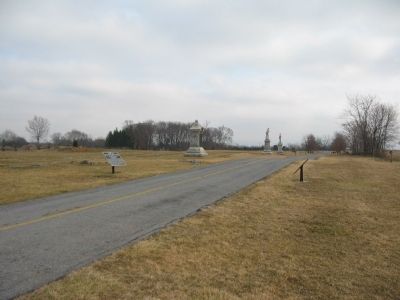
On the far left is Duryee's Brigade tablet. On the right facing away from the camera is Lawton's Brigade (CS) tablet. The 104th New York monument is in the middle to the left of the road. In the distance beyond are the 128th and 137th Pennsylvania Regiment monuments.
Photographed By Craig Swain, February 9, 2008
5. Lawton's Georgians In the Cornfield
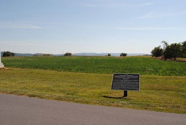
Looking north into the cornfield from the marker location. The Georgians bore the brunt of the morning attacks. As the action opened, the brigade had skirmishers extended across the cornfield from east to west. Facing parts of three different Federal divisions, they fought a costly delaying action, falling back out of the cornfield.
Credits. This page was last revised on October 23, 2017. It was originally submitted on February 24, 2008, by Craig Swain of Leesburg, Virginia. This page has been viewed 951 times since then and 27 times this year. Photos: 1. submitted on February 24, 2008, by Craig Swain of Leesburg, Virginia. 2. submitted on October 22, 2015, by Brian Scott of Anderson, South Carolina. 3. submitted on February 24, 2008, by Craig Swain of Leesburg, Virginia. 4. submitted on October 22, 2015, by Brian Scott of Anderson, South Carolina. 5. submitted on February 24, 2008, by Craig Swain of Leesburg, Virginia.
