Richmond-Andrus Mill Site
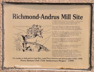
The 1915 History of Perry reports that the sawmill was operational. With 93 years in business, it was the oldest industry in town.
In 1949, the building was converted to the first frozen food locker plant in the area. In 1999, the building houses the Rich Plan/Shared Harvest Company. The sluice-way in the foreground is that of the Hamlin Flax Mill, which was likely located near the present Perry Herald building.
(The view in the image to the left is from a photo taken from the Borden Avenue bridge, looking south.) Compare the image to the Rich Plan/Shared Harvest building. Note the window placement and the waterfall. The millpond, once located at the present day village parking lot, supplied water.
This marker is dedicated to Clark Rice, noted Perry historian and photographer (1921-1999
Erected 1999 by Perry Rotary Club 75th Anniversary Project.
Topics and series. This historical marker is listed in these topic lists: Industry & Commerce • Man-Made Features. In addition, it is included in the Rotary International series list. A significant historical year for this entry is 1822.
Location. 42° 43.077′ N, 78°
Other nearby markers. At least 8 other markers are within 2 miles of this marker, measured as the crow flies. Historic Water Trough (within shouting distance of this marker); Robeson Cutlery Company (about 400 feet away, measured in a direct line); Wycoff Harvester Company (about 400 feet away); Andrus Mill Pond (about 500 feet away); First United Methodist Church (about 600 feet away); Silver Lake Mills of Perry (approx. 0.2 miles away); Old Burying Ground (approx. 0.2 miles away); Pioneer Cabin (approx. 1.2 miles away). Touch for a list and map of all markers in Perry.
Credits. This page was last revised on June 16, 2016. It was originally submitted on August 10, 2012, by Yugoboy of Rochester, New York. This page has been viewed 494 times since then and 20 times this year. Photos: 1, 2, 3, 4. submitted on August 10, 2012, by Yugoboy of Rochester, New York. • Bill Pfingsten was the editor who published this page.


