Near Kingsland in Camden County, Georgia — The American South (South Atlantic)
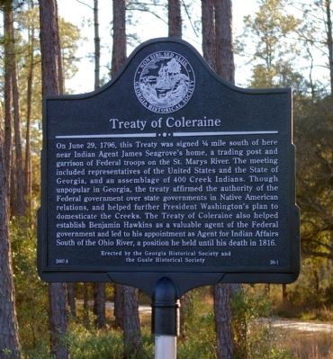
Treaty of Coleraine
Erected 2007 by Georgia Historical Society and the Guale Historical Society. (Marker Number 20-1.)
Topics and series. This historical marker is listed in this topic list: Native Americans. In addition, it is included in the Former U.S. Presidents: #01 George Washington, and the Georgia Historical Society series lists. A significant historical month for this entry is June 1963.
Location. 30° 50.339′ N, 81° 53.902′ W. Marker is near Kingsland, Georgia, in Camden County. Marker is on Okefenokee Parkway (Georgia Route 40) one mile west of Ga. Hwy 110, on the left when traveling south. Touch for map. Marker is in this post office area: Kingsland GA 31548, United States of America. Touch for directions.
Other nearby markers. At least 8 other markers are within 9 miles of this marker, measured as the crow flies. Kings Ferry (approx. 5 miles away in Florida); Henry Roddenberry (approx. 6.4 miles away); Charlton County (approx. 6.4 miles away); Central Dixie Highway (approx. 6.4 miles away); Center Village or Centerville (approx. 6.4 miles away); Okefenokee Swamp (approx. 6.7 miles away); Sardis Church (approx. 8.2 miles away); Trader's Hill (Fort Alert) (approx. 8.7 miles away).
Regarding Treaty of Coleraine. The site of the treaty is on private property. The owners request that the public respect their privacy.
Credits. This page was last revised on March 9, 2022. It was originally submitted on February 9, 2009, by David Seibert of Sandy Springs, Georgia. This page has been viewed 1,966 times since then and 30 times this year. Last updated on October 10, 2012, by George Varn Jr. of Jacksonville, Florida. Photo 1. submitted on February 9, 2009, by David Seibert of Sandy Springs, Georgia. • Bill Pfingsten was the editor who published this page.
