Near Nancy in Pulaski County, Kentucky — The American South (East South Central)
Mistaken Identity - A Deadly Error
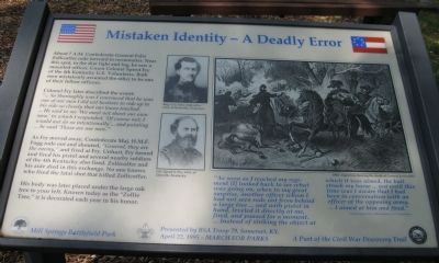
Colonel Fry later described the event: "... So thoroughly was I convinced that he was one of our men I did not hesitate to ride up to his side so closely that our knees touched. ... He said to me 'We must not shoot our own men,' to which I responded, 'Of course not; I would not do so intentionally' ... and pointing ... he said 'Those are our men.'"
As Fry moved away, Confederate Major H.M.F. Fogg rode out and shouted, "General, they are the enemy," and fired at Fry. Unhurt, Fry turned and fired his pistol and several nearby soldiers of the 4th Kentucky also fired. Zollicoffer and his aide died in this exchange. No one knows who fired the fatal shot that killed Zollicoffer.
His body was later placed under the large oak tree to your left. Known today as the "Zollie Tree," it is decorated each year in his honor.
(illustrations)
The marker contains the following drawings:
Portraits of Brigadier General Felix Zollicoffer, CSA, of Nashville, Tennessee and Colonel Speed S. Fry, USA, of Danville, Kentucky
1862 engraving showing the death of General Zollicoffer captioned, "As soon as I reached my regiment I looked back to see what was going on, when to my great surprise, another officer whom I had not seen rode out from behind a large tree ... and with pistol in hand, leveled it directly at me, fired, and paused for a moment. ... Instead of striking the object at which it was aimed, the ball struck my horse ... not until this time was I aware that I had been in conversation with an officer of the opposing army. ... I aimed at him and fired." - Colonel Speed Fry, 4th Kentucky U.S. Volunteers
Erected 1995 by Mill Springs Battlefield Park.
Topics. This historical marker is listed in this topic list: War, US Civil. A significant historical year for this entry is 1862.
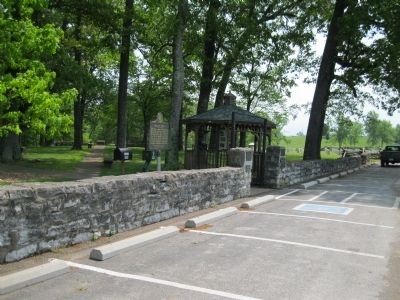
Location. This marker has been replaced by another marker nearby. It was located near 37° 3.343′ N, 84° 44.357′ W. Marker was near Nancy, Kentucky, in Pulaski County. Marker could be reached from State Road 235, 0.1 miles south of State Road 761, on the left when traveling south. Marker is inside a stone wall near the gate to Zollicoffer Park or Cemetery. It is with several other markers, monuments, and the "Zollie Tree." Parking is beside the street outside the wall. This is at Stop 2 of the Mill
Springs Battlefield Driving Tour. Touch for map. Marker was in this post office area: Nancy KY 42544, United States of America. Touch for directions.
Other nearby markers. At least 8 other markers are within walking distance of this location. Felix K. Zollicoffer / "Zollie Tree" (here, next to this marker); The Zollie Tree (here, next to this marker); A Fatal Mistake (a few steps from this marker); Gen'l Felix K. Zollicoffer (a few steps from this marker); Mill Springs Battlefield (a few steps from this marker); Confederate Mass Grave Memorial (within shouting distance of this marker); Dawn of Battle (within shouting distance of this marker); Confederate Dead (within shouting distance of this marker). Touch for a list and map of all markers in Nancy.
More about this marker. This marker was replaced by a new one named A Fatal Mistake (see nearby markers).
Credits. This page was last revised on August 2, 2019. It was originally submitted on January 31, 2013, by David Graff of Halifax, Nova Scotia. This page has been viewed 495 times since then and 10 times this year. Photos: 1, 2. submitted on January 31, 2013, by David Graff of Halifax, Nova Scotia. • Craig Swain was the editor who published this page.

