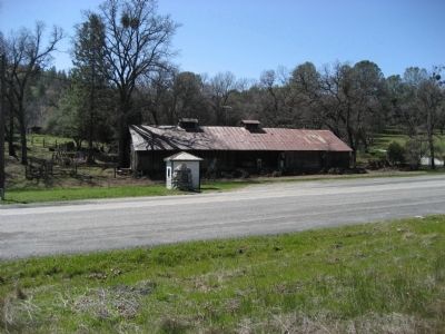
Near Tuolumne in Tuolumne County, California — The American West (Pacific Coastal)
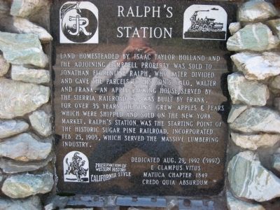
Ralph’s Station
Erected 1992 by E Clampus Vitus, Matuca Chapter 1849. (Marker Number 5997.)
Topics and series. This historical marker is listed in these topic lists: Agriculture • Railroads & Streetcars • Settlements & Settlers. In addition, it is included in the E Clampus Vitus series list. A significant historical date for this entry is February 25, 1938.
Location. 37° 57.897′ N, 120° 16.235′ W. Marker is near Tuolumne, California, in Tuolumne County. Marker is at the intersection of Tuolumne Road (Local Route E17) and Soulsbyville Road, on the right when traveling east on Tuolumne Road. Marker is 4.9 miles east of intersection of Mono Way (old Highway 108) and Tuolumne Road. Touch for map. Marker is in this post office area: Tuolumne CA 95379, United States of America. Touch for directions.
Other nearby markers. At least 8 other markers are within 2 miles of this marker, measured as the crow flies. Soulsbyville (approx. 1.4 miles away); Westside Flume & Lumber Company (approx. 1.4 miles away); a different marker also named Soulsbyville (approx. 1.4 miles away); Cherokee (approx. 1.6 miles away); West Side Memorial Park (approx. 1.8 miles away); Tuolumne Memorial Hall (approx. 1.8 miles away); Tuolumne (formerly called Summersville) (approx. 1.9 miles away); The Joseph Lord House (approx. 2 miles away). Touch for a list and map of all markers in Tuolumne.

Photographed By Richard Wisehart, March 22, 2008
2. Ralph's Station Marker
View is southerly. Marker is on south side of Tuolumne Road at intersection with Soulsbyville Road, 4.9 miles east of intersection of Mono Way (old Highway 108) and Tuolumne Road; 2.0 miles west of the town of Tuolumne. Sonora is to the right and Tuolumne is to the left.
Credits. This page was last revised on November 7, 2019. It was originally submitted on March 28, 2008, by Richard Wisehart of Sonora, California. This page has been viewed 1,948 times since then and 47 times this year. Photos: 1, 2. submitted on March 28, 2008, by Richard Wisehart of Sonora, California. • Kevin W. was the editor who published this page.
