Sharpsburg in Washington County, Maryland — The American Northeast (Mid-Atlantic)
Hood's Division, Longstreet's Command
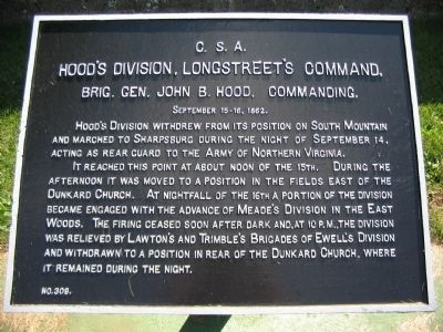
Hood's Division, Longstreet's Command,
Brig. Gen. John B. Hood, Commanding.
September 15-16, 1862.
Hood's Division withdrew from its position on South Mountain and marched to Sharpsburg during the night of September 14, acting as rear guard to the Army of Northern Virginia.
It reached this point at about noon of the 15th. During the afternoon it was moved to a position in the fields east of the Dunkard Church. At nightfall of the 16th a portion of the division became engaged with the advance of Meade's Division in the East Woods. The firing ceased soon after dark and, at 10 p.m., the division was relieved by Lawton's and Trimble's Brigades of Ewell's Division and withdrawn to a position in rear of the Dunkard Church, where it remained during the night.
Erected by Antietam Battlefield Board. (Marker Number 309.)
Topics and series. This historical marker is listed in this topic list: War, US Civil. In addition, it is included in the Antietam Campaign War Department Markers series list. A significant historical month for this entry is September 1704.
Location. 39° 27.595′ N, 77° 44.548′ W. Marker is in Sharpsburg, Maryland, in Washington County. Marker is on Boonsboro Pike (State Highway 34), on the right when traveling east. Located in a Confederate tablet cluster just to the west of the National Cemetery entrance, stop eleven of the driving tour of Antietam Battlefield. Touch for map. Marker is in this post office area: Sharpsburg MD 21782, United States of America. Touch for directions.
Other nearby markers. At least 8 other markers are within walking distance of this marker. Longstreet's Command (here, next to this marker); Reserve Artillery, Longstreet's Command (here, next to this marker); a different marker also named Longstreet's Command (here, next to this marker); a different marker also named Longstreet's Command (here, next to this marker); a different marker also named Longstreet's Command (a few steps from this marker); D.R. Jones' Division, Longstreet's Command (a few steps from this marker); a different marker also named D.R. Jones' Division, Longstreet's Command (a few steps from this marker); Evans' Brigade, Longstreet's Command (within shouting distance of this marker). Touch for a list and map of all markers in Sharpsburg.
Also see . . .
1. Antietam Battlefield. National Park Service site. (Submitted on April 20, 2008, by Craig Swain of Leesburg, Virginia.)
2. Hood's Division, Longstreet's Command. (Submitted on April 20, 2008, by Craig Swain of Leesburg, Virginia.)

Photographed By Craig Swain
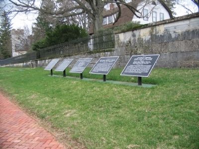
2. Confederate Tablet Cluster near the Entrance to the Cemetery
From left to right these are: Longstreet's Command, September 14-16 (number 303); Longstreet's Command, September 17 (number 304); Reserve Artillery, Longstreet's Command, September 15-16 (number 305); Hood's Division, September 15-16 (number 309); and Reserve Artillery, Hood's Division, September 15-16 (number 311). Three additional tablets stand to the right of these.

Photographed By Craig Swain, April 6, 2008
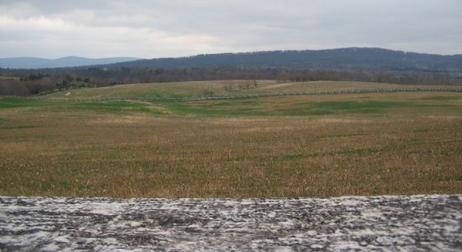
3. Hood's Position on September 15th
Having conducted rear guard operations as the army fell back from South Mountain. Arriving on the west side of Antietam Creek, the division was posted to the south side of Boonsboro Pike (on the left here), on high ground that later became the National Cemetery. This photo was taken over the wall of the Cemetery. The Division had marched from positions on South Mountain, which can be seen as the most distant ridge line on the far left.
Credits. This page was last revised on September 29, 2017. It was originally submitted on April 20, 2008, by Craig Swain of Leesburg, Virginia. This page has been viewed 997 times since then and 14 times this year. Photos: 1, 2, 3. submitted on April 20, 2008, by Craig Swain of Leesburg, Virginia.
