Fielding Hurst and Purdy
Behaving Badly
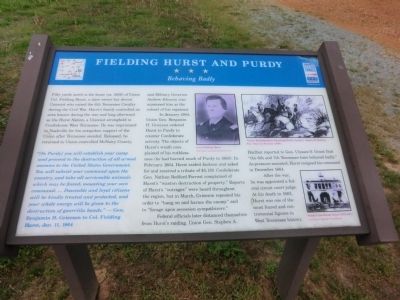
Fifty yards north is the home (ca. 1856) of Union Col. Fielding Hurst, a slave owner but devout Unionist who raised the 6th Tennessee Cavalry during the Civil War. Hurstís family controlled an area known during the war and long afterward as the Hurst Nation, a Unionist stronghold in Confederate West Tennessee. He was imprisoned in Nashville for his outspoken support of the Union after Tennessee seceded. Released, he returned to Union-controlled McNairy County, and Military Governor Andrew Johnson commissioned him as the colonel of his regiment.
In January 1864, Union Gen. Benjamin H. Grierson ordered Hurst to Purdy to counter Confederate activity. The objects of Hurstís wrath complained of his ruthlessness (he had burned much of Purdy in 1863). In February 1864, Hurst raided Jackson and asked for and received a tribute of $5,139. Confederate Gen. Nathan Bedford Forrest complained of Hurstís “wanton destruction of property.” Reports of Hurstís “outrages” were heard throughout the region, but in March, Grierson repeated his order to “hang on and harass the enemy” and to “forge upon secession sympathizers.”
Federal officials later distanced themselves from Hurstís raiding. Union Gen. Stephen A. Hurlbut reported to Gen. Ulysses S. Grant that “the 6th and 7th Tennessee have
behaved badly.” As pressure mounted, Hurst resigned his command in December 1864.After the war, he was appointed a federal circuit court judge. At his death in 1882, Hurst was one of the most feared and controversial figures in West Tennessee history.
“(In Purdy) you will establish your camp and proceed to the destruction of all armed enemies to the United States Government. You will subsist your command upon the country, and take all serviceable animals which may be found, mounting your own command. ÖPeaceable and loyal citizens will be kindly treated and protected, and your whole energy will be given to the destruction of guerrilla bands.”
---Gen. Benjamin H. Grierson to Col. Fielding Hurst, Jan. 11, 1864
(Inscription under the photo in the upper center)
Col. Fielding Hurst-Courtesy www.hurstnation.com
(Inscription under the photo in the upper right)
“Union Bushwackers Attacking Rebel Cavalry,” Junious H. Browne, Four years in Secessia (1866)
(Inscription under the photo in the lower right)
Purdy Courthouse (stood 1830-1881) Courtesy Vicki Burress Roach
Erected by Tennessee Civil War Trails.
Topics and series. This historical marker is listed in this topic list: War, US Civil. In addition, it is included
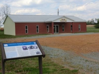
Location. 35° 13.884′ N, 88° 31.902′ W. Marker is in Purdy, Tennessee, in McNairy County. Marker is on Prudy-Beauty Hill Road. The marker is on the grounds of the Prudy Community Center. Touch for map. Marker is in this post office area: Bethel Springs TN 38315, United States of America. Touch for directions.
Other nearby markers. At least 8 other markers are within 6 miles of this marker, measured as the crow flies. Purdy (approx. 3.2 miles away); Approach to Shiloh (approx. 3.8 miles away); First Courthouse of McNairy County (approx. 3.9 miles away); The Hurst Nation (approx. 4.2 miles away); Liberty Church (approx. 4.2 miles away); Buford Hayse Pusser (approx. 4.4 miles away); McNairy County Military Park (approx. 5.3 miles away); Peach Street Apartment (approx. 5.3 miles away).
Credits. This page was last revised on June 16, 2016. It was originally submitted on June 27, 2014, by Don Morfe of Baltimore, Maryland. This page has been viewed 1,797 times since then and 78 times this year. Photos: 1, 2, 3. submitted on June 27, 2014, by Don Morfe of Baltimore, Maryland. • Bill Pfingsten was the editor who published this page.


