Lockport in Niagara County, New York — The American Northeast (Mid-Atlantic)
Lockport Municipal Building
Inscription.
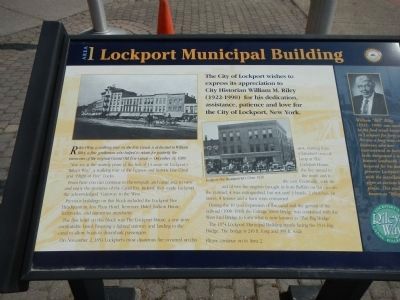
The City of Lockport wishes to express its appreciation to City Historian William H. Riley (1922-1990) for his dedication, assistance, patience and love for the City of Lockport, New York.
Riley’s Way: a walking tour on the Erie Canal is dedicated to William Riley, a fine gentleman who helped to retain for posterity the memories of true original Grand Old Erie Canal. - December 31, 1989
You are at the starting point of the first of 14 areas on Lockport’s “Riley’s Way”, a walking tour of the famous and historic Erie Canal and “Flight of Five” Locks.
From here you can continue to the towpath and canal area to view and enjoy the treasures of the Canal Era. Indeed, they made Lockport the acknowledged “Gateway to the West.”
Previous buildings on this block included the Lockport Fire Headquarters, Lox Plaza Hotel, Kenmore Hotel, Judson House, Tenbrooks, and numerous merchants.
The first hotel on this block was the Lockport House, a one story comfortable hotel, boasting a lighted stairway and landing to the canal to allow boats to disembark passengers.
On November 2, 1854 Lockport’s most disastrous fire occurred on this spot. Starting from a knocked over oil lamp at the Lockport House, the fire spread to the north and to the east. Eventually, with the aid of two fire engines brought in from Buffalo on flat cars on the railroad, it was extinguished, but not until 3 hotels, 2 churches, 18 stores, 8 houses and a barn were consumed.
During the 10 year expansion of the canal and the growth of the railroad (1908-1918) the Cottage Street Bridge was combined with the West End Bridge to form what is now known as “The Big Bridge”.
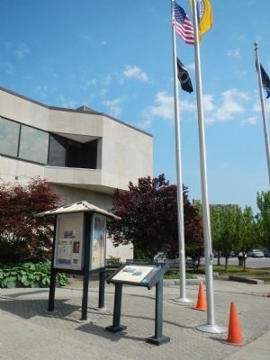
The 1974 Lockport Municipal Building stands facing the 1914 Big Bridge. The bridge is 249 ft. long and 399 ft. wide.
Sidebar on the right
William “Bill” Riley (1922-1990)
was involved in the food retail business in Lockport for forty years. He was a long-time city historian who was instrumental in having the canal locks designated a national historic landmark. He was honored for his dedication to preserve Lockport’s Erie Canal with the installation of fourteen signs at various historic places. This trail is now known as “Riley’s Way.”
Erected by New York State Canals. (Marker Number 1.)
Topics and series. This historical marker is listed in these topic lists: Disasters • Waterways & Vessels. In addition, it is included in the Erie Canal series list. A significant historical date for this entry is November 2, 1854.
Location. 43° 10.179′ N, 78° 41.713′ W. Marker is in Lockport, New York, in Niagara County. Marker is on Cottage Street near Niagara Street. Touch for map. Marker is in this post office area: Lockport NY 14094, United States of America. Touch for directions.
Other nearby markers. At least 8 other markers are within walking distance of this marker. The “Big Bridge” (within shouting distance of this marker); Canal Comparisons (within shouting distance of this marker); W.H. Upson Coal Company Building (about 300 feet away, measured in a direct line); a different marker also named Big Bridge (about 300 feet away); Upson Park (about 400 feet away); “Lockport Flight of Five” (about 400 feet away); Tour Boat Then & Now (about 400 feet away); Lower Lock Construction (about 500 feet away). Touch for a list and map of all markers in Lockport.
More about this marker. The address for the Lockport Municipal Building is 10-14 Niagara Street.
Credits. This page was last revised on June 16, 2016. It was originally submitted on September 7, 2014, by Barry Swackhamer of Brentwood, California. This page has been viewed 527 times since then and 28 times this year. Photos: 1, 2. submitted on September 7, 2014, by Barry Swackhamer of Brentwood, California. • Bill Pfingsten was the editor who published this page.

