Saint John in Saint John County, New Brunswick — The Atlantic Provinces (North America)
Fort Howe
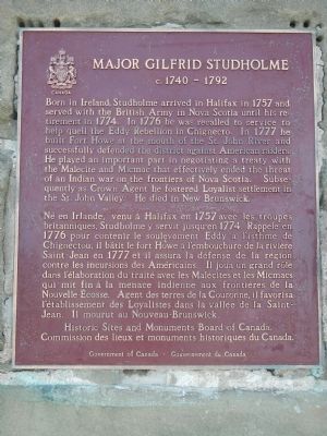
Major Gilfrid Studholme
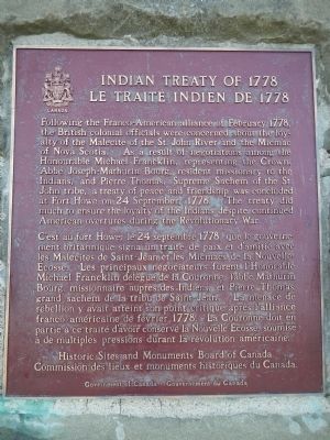
— Indian Treaty of 1778/Le Traité Indien de 1778 —
English
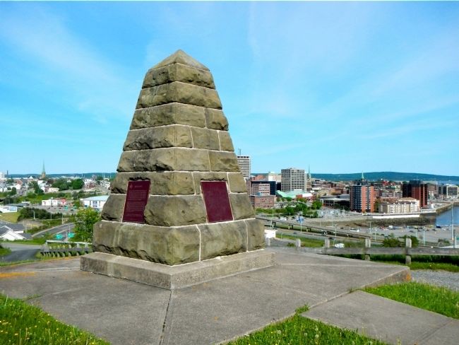
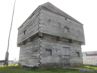
Late in 1777 Major Gilfred Studholme hurriedly fortified this ridge overlooking the mouth of the Saint John River. Throughout the remainder of the American Revolutionary War the presence of Fort Howe, its guns and garrison, guarded the settlement at the river’s mount from attack by American Privateers, a minority of disaffected settlers, and the local Indians with whom a treaty was made here in 1778. Allowed to decay after 1783, the fort was once more manned and armed during the War of 1812. The garrison was withdrawn in 1821, but the property remained a military reserve until 1914.
French
À la fin de 1777, le major Gilfred Studholme fortifia à la hâte cette colline qui domine l’embouchure de la rivière Saint-Jean. Jusqu’à la fin de la guerre de l’Indépendance américaine, le fort Howe protégea la colonie des attaques menées par des corsaires américains ou par un groupe de colons mécontents. Les Indiens de la région constituaient aussi un menace, mais on signa un traité avec eux, ici même, en 1778. Négligé après 1783, le fort fut une fois de plus utilisé pendant le Guerre de 1812, En 1821, la garnison fut retiree mais l’endroit demeura une réserve militaire jusqu’en 1914.
c. 1740-1792
English
Born in Ireland, Studholme arrived in Halifax in 1757 and served with the British Army in Nova Scotia until his retirement in 1774. In 1776 he was recalled to serve to help quell the Eddy Rebellion in Chignecto. In 1777 he built Fort Howe at the mouth of the St. John River and successfully defended the district against American raiders. He played an important part in negotiating a treaty with the Malecite and Micmac that effectively ended the threat of an Indian war on the frontiers of Nova Scotia. Subsequently as Crown Agent he fostered Loyalist settlements in the St. John Valley. He died in New Brunswick.
French
Né en Irlande, venu à Halifax en 1757 avec les troupes britanniques, Studholme y servit jusqu’en 1774. Rappelé en 1776 pour contenir le soulèvement Eddy à l’isthme de Chignectou, il bâtit le fort Howe à l’embouchure de la rivière Saint-Jean en 1777 et il assura la défense de la région contre les incursions des Américains. Il joua un grand rôle dans l’élaboration du traité avec les Malécites et les Micmacs qui mit fin à la menace indienne aux frontières de la Nouvelle-Écosse. Agent de terres de la Couronne, il favorisa l’établissement des Loyalists dans la vallée de la Saint-Jean. Il mourut au Nouveau-Brunswick.
Le Traité Indien de 1778
English
Following the Franco-American alliance of February 1778, the British colonial officials were concerned about the loyalty of the Malecite of the St. John River and the Micmac of Nova Scotia. As a result of negotiations among the Honourable Michael Francklin, representing the Crown, Abbe Joseph-Mathurin Bourg, resident missionary to the Indians, and Pierre Thomas, Supreme Sachem of the St. John tribe, a treaty of peace and friendship was concluded at Fort Howe on 24 September, 1778. The treaty did much to ensure the loyalty of the Indians despite continued American overtures during the Revolutionary War.
French
C’est au fort Howe, le 24 septembre 1778, que le gouvernement britannique signa un traité de paix et d’amitié avec les Malécites de Saint-Jean et les Micmacs de la Nouvelle Écosse. Les principaux négociateurs furent l’Honorable Michael Francklin délégué de la Couronne, l’abbé Mathurin Bourg, missionnaire auprès de Indiens, et Pierre Thomas, grand sachem de la tribu de Saint-Jean. Le menace de rébellion y avait atteint son point critique après l’alliance franco-américaine de février 1778. La Couronne doit en partie à ce traité d’avoir conserve la Nouvelle-Écosse, soumise à de multiples pressions durant le révolution américaine.
Erected by Historic Sites and Monument Board of Canada/Commission de lieux et monuments historique du Canada.
Topics and series. This historical marker is listed in these topic lists: Forts and Castles • Native Americans • War, US Revolutionary. In addition, it is included in the Canada, Historic Sites and Monuments Board series list. A significant historical year for this entry is 1777.
Location. 45° 16.587′ N, 66° 4.38′ W. Marker is in Saint John, New Brunswick, in Saint John County. Marker is on Magazine Street close to Metcalf Street. Touch for map. Marker is at or near this postal address: 12 Magazine Street, Saint John NB E2K, Canada. Touch for directions.
Other nearby markers. At least 8 other markers are within walking distance of this marker. Fort La Tour (approx. 0.3 kilometers away); Menahkwesk "Saint John" (approx. 0.4 kilometers away); a different marker also named Fort La Tour (approx. 0.4 kilometers away); a different marker also named Fort La Tour (approx. 0.4 kilometers away); The Shards of Time (approx. 0.4 kilometers away); Saint John – The Working Port (approx. 0.4 kilometers away); Electrifying the Uptown (approx. 0.6 kilometers away); Defending the Harbour (approx. 0.6 kilometers away). Touch for a list and map of all markers in Saint John.
More about this marker. The Fort Howe monument is located on a circular road at the summit of Fort Howe park. Park roads are unnamed.
Also see . . .
1. Fort Howe - Wikipedia. The fort initially held 8 cannons, barracks for 100 men, 2 blockhouses, and an outer wall composed of fascines, sticks and sod. By 1778, the fort consisted of a more substantial blockhouse and barracks located within a palisade, as well as an abatis. (Submitted on September 28, 2014, by Barry Swackhamer of Brentwood, California.)
2. Fort Howe - Fortwiki. Established in 1777 during the Revolutionary War by Brigade Major Gilfrid Studholme and a detachment of soldiers on a hill overlooking the Saint John Harbor and the mouth of the Saint John River. The selected site overlooked the sites of previous fortifications (Fort La Tour and Fort Frederick (4)) and provide a sweeping view of the town and the harbor. (Submitted on September 28, 2014, by Barry Swackhamer of Brentwood, California.)
Credits. This page was last revised on June 16, 2016. It was originally submitted on September 28, 2014, by Barry Swackhamer of Brentwood, California. This page has been viewed 734 times since then and 39 times this year. Photos: 1, 2, 3, 4, 5, 6. submitted on September 28, 2014, by Barry Swackhamer of Brentwood, California. • Andrew Ruppenstein was the editor who published this page.


