Lenoir in Caldwell County, North Carolina — The American South (South Atlantic)
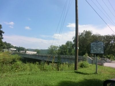
Fort Defiance
Home of William Lenoir, leader in Revolution & public affairs. Built 1788-92 and named for colonial fort on the site 4½ miles east.
Erected 2007 by North Carolina Office of Archives and History. (Marker Number N-1.)
Topics and series. This historical marker is listed in these topic lists: Colonial Era • Forts and Castles • War, US Revolutionary. In addition, it is included in the North Carolina Division of Archives and History series list.
Location. 35° 59.422′ N, 81° 33.521′ W. Marker is in Lenoir, North Carolina, in Caldwell County. Marker is at the intersection of Yadkin River Road (County Route 1560) and North Carolina Highway 268, on the right when traveling north on Yadkin River Road. Touch for map. Marker is in this post office area: Lenoir NC 28645, United States of America. Touch for directions.
Other nearby markers. At least 8 other markers are within 6 miles of this marker, measured as the crow flies. Patterson Mill (approx. ¼ mile away); Collett Leventhorpe (approx. 2.2 miles away); Caldwell County Courthouse (approx. 5.3 miles away); Hog Waller Market in Downtown Lenoir (approx. 5.3 miles away); United States Post Office (approx. 5.3 miles away); Belk's Department Store (approx. 5.4 miles away); Raiders in Lenoir (approx. 5.4 miles away); St. James Episcopal Church Labyrinth (approx. 5.4 miles away). Touch for a list and map of all markers in Lenoir.
Credits. This page was last revised on March 17, 2024. It was originally submitted on September 29, 2014, by Don Morfe of Baltimore, Maryland. This page has been viewed 522 times since then and 16 times this year. Photos: 1, 2. submitted on September 29, 2014, by Don Morfe of Baltimore, Maryland. • Bernard Fisher was the editor who published this page.

