Near Louisbourg in Cape Breton Region, Nova Scotia — The Atlantic Provinces (North America)
Louisbourg Harbour
Le port de Louisbourg
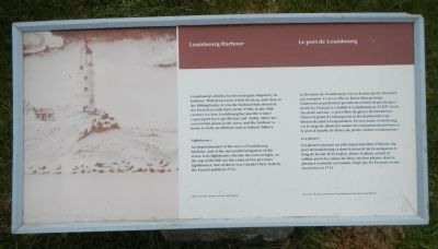
Louisbourg’s destiny has been largely shaped by its harbour. Well-protected, relatively deep and close to the fishing banks, it was the harbour that attracted the French to settle here in the 1700s. In the 19th century ice-free Louisbourg became the winter export port for Cape Breton coal. Today, there are several fish plants in the town, and the harbour is home to both an offshore and an inshore fishery.
Lighthouses
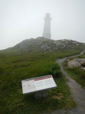
An important part of the story of Louisbourg harbour, and of the successful navigation of this coast, is its lighthouses. Beside the current light, on the top of the hill, are the ruins of two previous lighthouses. One of these was Canada’s first, built by the French and lit in 1734.
French:
La destinée de Louisbourg a été en bonne partie façonnée par son port. C’est en effet ce havre bien protégé, relativement profond et proche des bancs de pêche qui a incité les Français à s’établir à Louisbourg au XVIIIᵉ siècle. Au siècle suivant, ce port libre de glaces devint durant l’hiver le pointe d’embarquement du charbon du Cap-Breton destiné à l’exportation. De nos jours, Louisbourg est le siège de plusieurs usines de traitement du poisson et le port d’attache de flottes de pêche côtière et hauturière.
Les phares
Les phares ont joué un rôle important dans l’histoire du port de Louisbourg et dans la sécurité de la navigation le long de la côte de la région. Outre le phare actuel, la colline porte les ruines de deux anciens phares, dont le premier construit au Canada, érigé par les Français et mit en service en 1734.
Erected by Parks Canada.
Topics and series. This historical marker is listed in this topic list: Waterways & Vessels. In addition, it is included in the Acadian History, and the Lighthouses series lists. A significant historical year for this entry is 1734.
Location. 45° 54.398′ N, 59° 57.466′ W. Marker is near Louisbourg, Nova Scotia, in Cape Breton Region. Marker is on Havenside Road, on the left when traveling east. Touch for map. Marker is at or near this postal address: 573 Havenside Road, Louisbourg NS B1C 1P4, Canada. Touch for directions.
Other nearby markers. At least 8 other markers are within 3 kilometers of this marker, measured as the crow flies. Lighthouse Point (a few steps from this marker); French Garrison at Louisbourg (within shouting distance of this marker); First Lighthouse (within shouting distance of this marker); First Lighthouse Tower (within shouting distance of this marker); 19th-Century Lighthouse (within shouting distance of this marker); Kennelly Point (within shouting distance of this marker); The Lobster Fishery (approx. 0.6 kilometers away); Fortress of Louisbourg (approx. 2.1 kilometers away). Touch for a list and map of all markers in Louisbourg.
More about this marker. This marker is near the parking lot at the end of Havenside Road.

Photographed By Pierre Charles Canot, Engraver, 1768
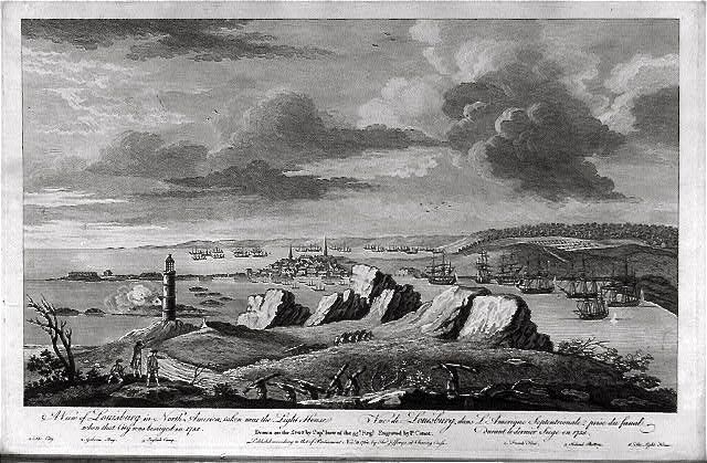
3. A view of Louisburg in North America, taken near the light house when that city was besieged…
Image courtesy of the Library of Congress. Full title of the image is: A view of Louisburg in North America, taken near the light house when that city was besieged in 1758 Vue de Louisburg, dans l'Amerique Septentrionale, prise du fanal durant le dernier siege en 1758 / / drawn on the spot by Capt. Ince of the 35th Regt. ; engraved by P. Canot.
Print shows view from the headlands above the lighthouse, with ships in the harbor, Louisbourg, Nova Scotia, center, and distant view of the harbor.
Print shows view from the headlands above the lighthouse, with ships in the harbor, Louisbourg, Nova Scotia, center, and distant view of the harbor.
Credits. This page was last revised on June 16, 2016. It was originally submitted on December 29, 2014, by Barry Swackhamer of Brentwood, California. This page has been viewed 407 times since then and 12 times this year. Photos: 1, 2. submitted on December 29, 2014, by Barry Swackhamer of Brentwood, California. 3. submitted on January 1, 2015. • Andrew Ruppenstein was the editor who published this page.

