Charlottetown in Queens County, Prince Edward Island — The Atlantic Provinces (North America)
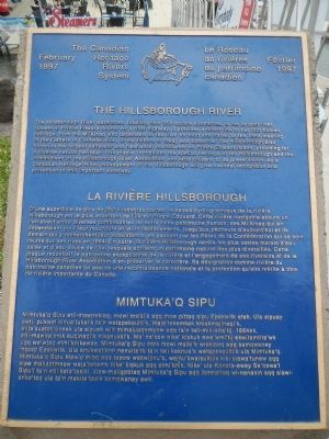
The Hillsborough River
La rivière Hillsborough
— Mimtuka’q Sipu —
The Hillsborough River watershed, totaling over 350 square kilometres, is the largest river system in Prince Edward Island. As a river highway, it provides a direct link to our rich human heritage, from the Mi’Kmaq who depended on the river for food and travel, to the 1864 meeting of the Fathers of Confederation, to the fishers of today and tomorrow. The Hillsborough also harbours the largest saltwater and freshwater marshlands on Prince Edward Island, providing for a diverse natural heritage. This plaque recognizes the special heritage of the Hillsborough and the commitment of the Hillsborough River Association and local citizens to its preservation. As a Canadian Heritage River, management of the Hillsborough will give national recognition and protection to this important waterway.
French:
D’une superficie de plus de 350 kilomètres carrés, le bassin hydrographique de la rivière Hillsborough est le plus important de l’Île-du-Prince-Édouard. Cette rivière navigable assure un lien direct entre diverses composantes de notre riche patrimoine humain: des Mi’Kmaq qui en dépendaient pour leur nourriture et leurs déplacements, jusqu’aux pêchers d’aujourd’hui et de demain qui y recherchent leur subsistance, en passant par les Pères de la Confédération qui se sont réunis sur ses rives en 1864. En outre, la rivière Hillsborough recèle les plus vastes marais d’eau salée et d’eau douce de I’Île, lesquels abritent un patrimoine naturel des plus diversifiés. Cette plaque reconnaît le patrimoine exceptionnel de la rivière et l’engagement de ses riverains et de la Hillsborough River Association à en préserver le caractère. Sa désignation comme rivière du patrimoine canadien lui assure un reconnaissance nationale et la protection qu’elle mérite à titre de rivière importante du Canada.
Mi’kmaq:
To read the Mi’kmaq text, click on the marker image to enlarge the photo.
Erected 1997 by The Canadian Heritage Rivers System / Le Réseau de rivières du patrimoine canadien.
Topics. This historical marker is listed in this topic list: Waterways & Vessels. A significant historical year for this entry is 1864.
Location. 46° 13.999′ N, 63° 7.167′ W. Marker is in Charlottetown, Prince Edward Island, in Queens County. Marker is on Prince Street close to Water Street, on the left when traveling south. Touch for map. Marker is at or near this postal address: 4 Prince Street, Charlottetown PE C1A 4P5, Canada. Touch for directions.
Other nearby markers. At least 8 other markers are within walking distance of this marker. Railway Car Shop (about 120 meters away, measured in a direct line); Threaded Together with Iron and Steel (about 120 meters away); Railway Brass Shop (about 150 meters away); Hillsborough Bridge
(about 180 meters away); Heralded Arrival… of the Circus (about 240 meters away); Survey of the Gulf and River St. Lawrence (approx. 0.2 kilometers away); William Henry Pope (1825 – 1879) (approx. 0.3 kilometers away); Great George Street Historic District (approx. 0.3 kilometers away). Touch for a list and map of all markers in Charlottetown.
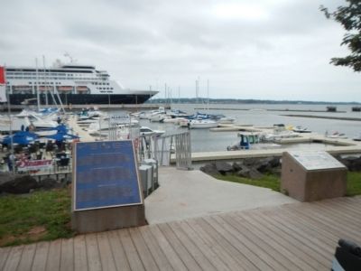
More about this marker. This marker is located at Historic Charlottetown Seaport's small boat marina.
Also see . . . Hillsborough River (Prince Edward Island) - Wikipedia. The river was the 27th in Canada and the first in Prince Edward Island to be nominated to the Canadian Heritage Rivers System. The river's estuary fronts heritage agricultural communities, Acadian dykes, historic shipyards, and the Charlottetown waterfront (where the Fathers of Confederation landed). The river's freshwater portion flows through pristine forests and farming areas, as well as extensive wetlands. The river during its freshwater run resembles a typical stream in other Canadian provinces..i (Submitted on January 8, 2015, by Barry Swackhamer of Brentwood, California.)
Credits. This page was last revised on June 16, 2016. It was originally submitted on January 8, 2015, by Barry Swackhamer of Brentwood, California. This page has been viewed 387 times since then and 12 times this year. Photos: 1, 2. submitted on January 8, 2015, by Barry Swackhamer of Brentwood, California. • Andrew Ruppenstein was the editor who published this page.

