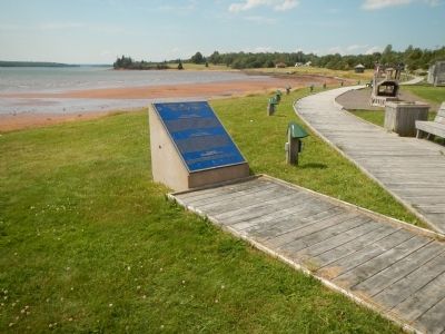
Georgetown in Kings County, Prince Edward Island — The Atlantic Provinces (North America)
Three Rivers
Les trois rivières
— Samkook —
The Three Rivers - Montague, Brudenell, and Cardigan - wind through towns, villages and communities in Kings County, draining into Cardigan Bay, known to the Mi’Kmaq people as Samkook (sandy shore). One of the first French settlements on Prince Edward Island, founded by Jean-Pierre Roma, grew here in the early 1700s, where the Brudenell and Montague Rivers meet at Georgetown Harbour. This same point of land also has the distinction of being the birthplace of Prince Edward Island’s father of Confederation, Andrew A. MacDonald. The Waters of the Three Rivers still flow, as they have for centuries, past farms, fisheries and shipyards, linking all those who live along their banks to each other, to the past and to the future. The natural beauty of the Three Rivers has been nurtured and protected through careful development and community stewardship. Designation of the Three Rivers as a Canadian Heritage River will safeguard its rich history and pristine natural beauty for generations to come.
French:
Les eaux du bassin hydrographique des trois rivières - composé des rivières Montague, Brudenell et Cardigan - traverse bon nombre de villes, de villages et de communautés du comté de Kings et se déversent dans la baie de Cardigan que les Mi’Kmaq appellent Samkook (rive sablonneuse). L’un des premiers établissements français de l’Île du Prince-Édouard, fondé par Jean-Pierre Roma, a vu le jour ici au confluent des rivières Brudenell et Montague, dans la port de Georgetown, au début des années 1700. Cet endroit est aussi le lieu de naissance d’un des Pères de la Confédération, Andrew A. MacDonald. Depuis des siècles, le bassin des trois rivières baigne des fermes, des pêches et des chantiers navals, reliant tous les habitants riverains les uns aux autres de même qu’aux richesses du passé et aux promesses de l’avenir. Un développement prudent et une intendance communautaire ont permis de préserver et de protéger le bassin des trois rivières dont la riche histoire et la beauté naturelle subsisteront pour les générations à venir grâce à son ajout au Réseau de rivières du patrimoine canadien.
Mi’Kmaq:
Kaskimtinaqnipunqek ki’s Mi’kmaq msit tami alta’pnik. Kaqi’sk wejita’pnik aq emittukutipnik Samcook. Ula tett pituey, pukwelkik nme’jk aq pukwelkik waisisk ta’n teli-apoqntik mimaju’naj wskwijinu’k. Elmi’knikewaq wskwijinu’k lita’suattaq ula sipa siawi klu’ktn aq waqame’ktn wjit wlo’timuow.
Erected 2004 by The Canadian Heritage Rivers System / Le Réseau de rivières du patrimoine canadien.
Topics. This historical marker is listed in this topic list: Waterways & Vessels. A significant historical year for this entry is 1700.
Location. 46° 10.831′ N, 62° 32.314′ W. Marker is in Georgetown, Prince Edward Island, in Kings County. Marker is on Richmond Street close to West Street, on the right when traveling west. Touch for map. Marker is at or near this postal address: 2 Richmond Street, Georgetown PE C0A 1L0, Canada. Touch for directions.
Other nearby markers. At least 8 other markers are within 21 kilometers of this marker, measured as the crow flies. Georgetown’s New Railway Station (a few steps from this marker); The Honorable Andrew Archibald (A.A.) Macdonald (approx. 0.6 kilometers away); Georgetown War Memorial (approx. 0.6 kilometers away); The Fishery at Murray Harbour / La Pêche À Murray Harbour (approx. 19.5 kilometers away); Cape Bear Lighthouse / Phare de Cape Bear (approx. 19.5 kilometers away); Getting the Train to the Track / L’Arrivée du Train sur la Voie Ferrée (approx. 19.5 kilometers away); The “Harbour” / Le « Harbour » (approx. 19.6 kilometers away); The Murray Harbour Branch / L’Embranchement Menant À Murray Harbour (approx. 19.6 kilometers away). Touch for a list and map of all markers in Georgetown.
More about this marker. The marker is next to the boat ramp.
Also see . . . The Three Rivers - CHRS. The Three Rivers flow southeasterly into Cardigan Bay between Lanching Point and Panmure Island on the eastern shore of Kings County, PEI. The watershed includes all lands drained by the Three Rivers, as well as the river corridors from headwater to estuary, as well as Boughton Island in Cardigan Bay. (Submitted on January 14, 2015, by Barry Swackhamer of Brentwood, California.)
Credits. This page was last revised on September 2, 2020. It was originally submitted on January 14, 2015, by Barry Swackhamer of Brentwood, California. This page has been viewed 701 times since then and 26 times this year. Photos: 1, 2. submitted on January 14, 2015, by Barry Swackhamer of Brentwood, California. • Andrew Ruppenstein was the editor who published this page.

