Haute-Ville in Québec in Communauté-Urbaine-de-Québec, — Central Canada (French-Canadian)
Protecting the Upper Town
Protéger la haute-ville

Photographed By Barry Swackhamer, July 28, 2014
1. Protecting the Upper Town Marker
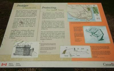
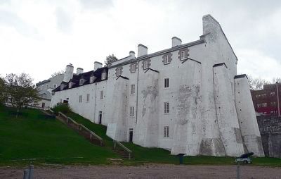
Captions (English / French): (bottom left) 1690 palisade and redoubt. Frontenac was hard pressed by time and decided to build a palisade of cedar pilings. Running the length of the palisade were eleven stone redoubts, which provided observation posts and postions for musket fire. / Palissade de redoute de 1690. Pressé par le temps, Frontenac a recours à une palissade faite de pieux de cèdre. Elle est entrecoupée de onze redoutes en pierre, servant de poste d’observation et pour le tir au fusil.; (top right) Three of the five lines of defence built in Québec’s upper town: 1690, 1693, 1712. / Trois des cinq lignes de défense construites à la haute ville de Québec: 1690, 1693, 1712.; (middle right) Remnants of the 1712 enceinte - the Dauphine Redoubt. In 1712, the wood pilings of southern half of the the 1693 earth-made enceinte were replaced with stone. To the north side were added two fortified towers, the Royal and Dauphine redoubts, which could be joined by walls in the event of an attack. / Témein de l’enceinte de 1712: la redoute Dauphine. En 1712, les pieux de l’enceinte de 1693 sont remplacés par de pierre dans sa moitié sud. Dans la portion nord, on innove en construisant deux nouvelles tours bastionnées, les redoutes Royale et Dauphine, que l’on prévoit relier par des murs en cas d’attaque.; (bottom right) The 1693 fortification was a rampart made of earth supported in front by wood pilings. Two stone gates, one of which led onto Saint-Jean Street, were built to allow entry through the fortification. In 1697 and 1709, temporary earthworks were added in front of the fortification to make it follow the slope of the land more closely. / La fortification de 1693 est un rempart en terre soutenu à l’avant par des pieux; elle est percée de deux portes en maçonnerie, dont l’une donne sur la rue Saint-Jean. En 1697 et en 1709. des ouvrages temporaires en terre seront ajoutés au devant pour pailler sa mauvaise adaptation au relief.
The promontory on which Québec is perched offered a natural defense against attackers. But its west flank, which gave way to open countryside, was vulnerable. Enormous sums of money would be spent to protect this side of the town.
In 1690, Governor Frontenac hastily put up a front line of defence to protect the western flank from William Phip’s British soldiers who sailed from Boston. This defense work was replaced by 1693, by a more elaborate fortification designed to withstand artillery fire.
The new fortification proved ineffective because it did not follow the uneven slope of the land. It was thus modified in 1712. The Dauphine Redoubt, located in Artillery Park, is one of the surviving parts of this new line of defence.
French:
Bien que le promontoire sur lequel repose Québec offre une protection naturelle contre les assaillants, la faiblesse en était le côté ouest, ouvert sur la campagne. D’énormes sommes seront investies pour protéger adéquatement ce côté de la ville.
Une première ligne de défense y est élevée à la hâte en 1690 par le gouverneur Frontenac pour se protéger des troupes anglaises de William Phips venues de Boston. Elle est démolie dès 1693 pour être remplacée par une fortification plus élaborée et conçue pour résister à l’artillerie.
Cette deuxième fortification, pue efficace car mal adaptée au relief inégal, est modifiée en 1712. La redoute Dauphine, située dans Parc de l’Artillerie, est l’un des éléments conservés de cette nouvelle ligne de défense.
Erected by Parks Canada / Parcs Canada.
Topics. This historical marker is listed in this topic list: Forts and Castles. A significant historical year for this entry is 1690.
Location. 46° 48.859′ N, 71° 12.769′ W. Marker is in Québec, in Communauté-Urbaine-de-Québec. It is in Haute-Ville. Marker is on Rue Mcmahon close to Rue d'Auteuil, on the left when traveling east. Touch for map. Marker is in this post office area: Québec G1R 4H5, Canada. Touch for directions.
Other nearby markers. At least 8 other markers are within walking distance of this marker. Artillery Park: The Barracks Sector (within shouting distance of this marker); Irish Roots in Old Québec (within shouting distance of this marker); The Artillery Park (about 150 meters away, measured in a direct line); Premier Hôpital au Canada (about 150 meters away); Site du palais de l'intendant / Intendant's Palace Site (about 150 meters away); Hôtel-Dieu de Québec (about 180 meters away); Chemin Royal (about 180 meters away); Michel Sarrazin (about 180 meters away). Touch for a list and map of all markers in Québec.
Credits. This page was last revised on February 9, 2023. It was originally submitted on March 13, 2015, by Barry Swackhamer of Brentwood, California. This page has been viewed 342 times since then and 21 times this year. Photos: 1, 2. submitted on March 13, 2015, by Barry Swackhamer of Brentwood, California. • Andrew Ruppenstein was the editor who published this page.
