Near Sekiu in Clallam County, Washington — The American West (Northwest)
Shipwreck Point
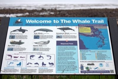
By the mid-1900’s, commercial whaling had pushed many great whale's to the edge of extinction. Through decades of conservation efforts, species like gray whales have rebounded. Others are endangered, and need our help to recover.
Local citizens and visitors to this coastline enjoy watching marine mammals all year long. Researchers watch for the return of the southern resident orcas in the spring.
From here, look for the spouts of passing whales, a splash as they breach, or their tails as they dive. On calm days, listen for the sound of their blows.
You may see sea otters, too. Once extinct in Washington waters, 69 sea otters were reintroduced to nearby La Push in 1969. Since then, the population has grown to over 1,000, and their territories have expanded up the strait. Look for one or dozens of the big otters floating on their backs near the kelp.
The Whale Trail is a series of sites around the region where you may view orcas and other whales or marine mammals from shore.
Erected by the Whale Trail, a nonprofit organization in partnership with Olympic Coast National Marine Sanctuary, People for Puget Sound, Seattle Aquarium, The Whale Museum, NOAA, and the Washington Department of Fish and Wildlife. (Marker Number 10.)
Topics. This historical marker is listed in these topic lists: Animals • Natural Features. A significant historical year for this entry is 1969.
Location. 48° 18.97′ N, 124° 26.869′ W. Marker is near Sekiu, Washington, in Clallam County. Marker is on Straight of Juan de Fuca Highway (State Highway 112) 8.7 miles west of Sekiu, on the right when traveling west. Touch for map. Marker is in this post office area: Sekiu WA 98381, United States of America. Touch for directions.
Other nearby markers. At least 1 other marker is within 6 miles of this marker, measured as the crow flies. Snow Creek (approx. 5.2 miles away).
More about this marker. This, and all Whale Trail markers contain color images, photographs, size information and description for orca (killer whale), gray whale, harbor seal, harbor porpoise, and California sea lion. Also shown are outlines of the Steller sea lion, Dall’s porpoise, humpback whale, sea otter, Minke whale, Pacific white-sided dolphin, and the river otter. A large map this corner of Washington shows the locations of the 17 Whale Trail markers and other Whale Trail sites, and the usual reminders of ecosystems
in trouble, how you can help, and a warning to keep your distance from marine wildlife for your protection and theirs.
Also see . . . The Whale Trail Website. “The Whale Trail is a series of sites around the Northwest where the public may view orcas, other whales and marine mammals from shore. Our mission is to inspire appreciation and stewardship of whales and our marine environment by establishing a network of viewing sites along the whales’ trails through the Salish Sea and the Pacific Coast.” (Submitted on May 25, 2015.)
Credits. This page was last revised on June 16, 2016. It was originally submitted on May 25, 2015, by J. J. Prats of Powell, Ohio. This page has been viewed 536 times since then and 30 times this year. Photos: 1, 2, 3. submitted on May 25, 2015, by J. J. Prats of Powell, Ohio.


