Walnutport in Northampton County, Pennsylvania — The American Northeast (Mid-Atlantic)
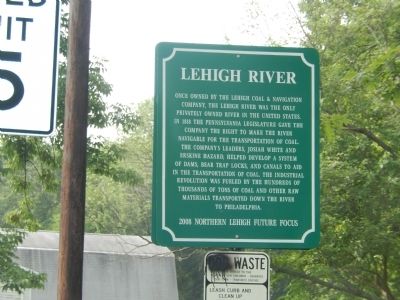
Lehigh River
Erected 2008 by Northern Lehigh Future Focus.
Topics. This historical marker is listed in these topic lists: Industry & Commerce • Waterways & Vessels. A significant historical year for this entry is 1818.
Location. 40° 45.172′ N, 75° 36.098′ W. Marker is in Walnutport, Pennsylvania, in Northampton County. Marker is on Lehigh Street. Touch for map. Marker is in this post office area: Walnutport PA 18088, United States of America. Touch for directions.
Other nearby markers. At least 8 other markers are within walking distance of this marker. Floating From Mine to Market (a few steps from this marker); Lehigh Canal (within shouting distance of this marker); Anchor Hotel (about 300 feet away, measured in a direct line); Walnutport (about 600 feet away); Pennsylvania House Slate Exchange Hotel (about 700 feet away); Slate Industry (approx. 0.2 miles away); Lehigh Valley Railroad Station (approx. 0.2 miles away); Kern Settlers (approx. 0.2 miles away). Touch for a list and map of all markers in Walnutport.
Credits. This page was last revised on June 16, 2016. It was originally submitted on July 15, 2015, by Don Morfe of Baltimore, Maryland. This page has been viewed 322 times since then and 11 times this year. Photos: 1, 2. submitted on July 15, 2015, by Don Morfe of Baltimore, Maryland. • Bill Pfingsten was the editor who published this page.

