Guernsey in Platte County, Wyoming — The American West (Mountains)
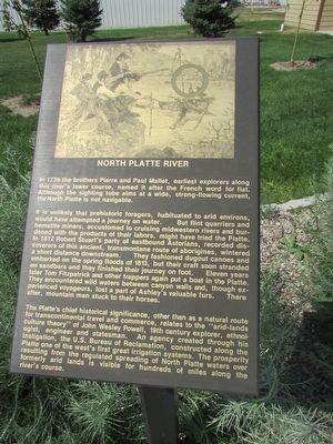
North Platte River
In 1739 the brothers Pierre and Paul Mallet, earliest explorers along this river’s lower course, named it after the French word for flat. Although the sighting tube aims at a wide, strong-flowing current, the North Platte is not navigable.
It is unlikely that prehistoric foragers, habituated to arid environs, would have attempted a journey on water. But flint quarries and hematite miners, accustomed to cruising Midwestern rivers and burdened with the products of their labors, might have tried the Platte. In 1812 Robert Stuart’s party of eastbound Astorians, recorded discoverers of this ancient, transmontane route of aborigines, wintered a short distance downstream. They fashioned dugout canoes and embarked on the spring floods of 1813, but their craft soon stranded on sandbars and they finished their journey on foot. Eleven years later Tom Fitzpatrick and other trappers again put a boat in the Platte. They encountered wild waters between canyon walls and, though experienced voyageurs, lost a part of Ashley’s valuable furs. There after, mountain men stuck to their horses.
The Platte’s chief historical significance, other than as a natural route for transcontinental travel and commerce, relates to the “arid-lands culture theory” of John Wesley Powell, 19th century explorer, ethnologist, engineer and statesman. An agency created through his instigation, the U.S. Bureau of Reclamation, constructed along the Platte one of the west’s first great irrigation systems. The prosperity resulting from the regulated spreading of North Platte waters over formerly arid lands is visible for hundreds of miles along the river’s course.
Topics. This historical marker is listed in this topic list: Waterways & Vessels. A significant historical year for this entry is 1739.
Location. 42° 16.15′ N, 104° 44.471′ W. Marker is in Guernsey, Wyoming, in Platte County. Marker is on S Wyoming Avenue, on the left when traveling south. Touch for map. Marker is in this post office area: Guernsey WY 82214, United States of America. Touch for directions.
Other nearby markers. At least 8 other markers are within walking distance of this marker. Register Cliffs (here, next to this marker); Guernsey Pipeline Station (here, next to this marker); Fort Laramie (here, next to this marker); Mexican Hill (here, next to this marker); Guernsey – Frederick Ranch (a few steps from this marker); Sand Point (a few steps from this marker); Laramie Peak (a few steps from this marker); The Burlington – Northern Railroad (a few steps from this marker). Touch for a list and map of all markers in Guernsey.
Credits. This page was last revised on June 16, 2016. It was originally submitted on August 9, 2015, by Bill Coughlin of Woodland Park, New Jersey. This page has been viewed 380 times since then and 9 times this year. Photos: 1, 2. submitted on August 9, 2015, by Bill Coughlin of Woodland Park, New Jersey.

