Allatoona in Bartow County, Georgia — The American South (South Atlantic)
The Foot Bridge
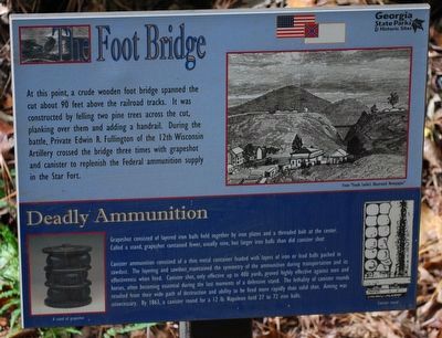
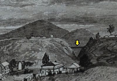
At this point, a crude wooden bridge spanned the cut about 90 feet above the railroad tracks. It was constructed by felling two pine trees across the cut, planking over them and adding a handrail. During the battle, Private Edwin R. Fullington of the 12th Wisconsin Artillery crossed the bridge three times with grapeshot and canister to replenish the Federal ammunition supply in the Star Fort.
(sidebar)
Deadly Ammunition
Grapeshot consisted of layered iron balls held together by iron plates and a threaded bolt at the center. Called a stand, grapeshot contained fewer, usually nine, but larger iron balls than did canister shot.
Canister ammunition consisted of a thin metal container loaded with layers of iron or lead balls packed in sawdust. The layering and sawdust maintained the symmetry of the ammunition during transport and its effectiveness when fired. Canister shot, only effective up to 400 yards, proved highly effective against men and horses, often becoming essential during the last moments of a defensive stand. The lethality of canister rounds resulted from their wide path of destruction and ability to be fired more rapidly than solid shot. Aiming was unnecessary. By 1863, a canister round for a 12 lb. Napoleon held 27 to 72 iron balls.
Erected by Georgia State Parks & Historical Sites.
Topics. This historical marker is listed in this topic list: War, US Civil. A significant historical year for this entry is 1863.
Location. 34° 6.967′ N, 84° 43.013′ W. Marker is in Allatoona, Georgia, in Bartow County. Marker is on Old Alltatoona Road SE, 0.4 miles north of Allatoona Landing Road SE, on the right when traveling north. Located inside The Cut to the left, about half-way through. Touch for map. Marker is at or near this postal address: 632 Old Allatoona Road SE, Cartersville GA 30121, United States of America. Touch for directions.
Other nearby markers. At least 8 other markers are within walking distance of this marker. Grave of the Unknown Hero (here, next to this marker); Rowett's Redoubt (within shouting distance of this marker); The Deep Cut (within shouting distance of this marker); Assault On The Star Fort (about 300 feet away, measured in a direct line); Inside the Star Fort (about 300 feet away); Confederate Withdrawal (about 400 feet away); 4th Minnesota Regimental Headquarters (about 500 feet away); Military Service Road (about 600 feet away). Touch for a list and map of all markers in Allatoona.
Credits. This page was last revised on June 28, 2019. It was originally submitted on August 18, 2015, by Brandon Fletcher of Chattanooga, Tennessee. This page has been viewed 438 times since then and 23 times this year. Photos: 1, 2, 3. submitted on August 18, 2015, by Brandon Fletcher of Chattanooga, Tennessee. • Bernard Fisher was the editor who published this page.


