Near Pocomoke City in Worcester County, Maryland — The American Northeast (Mid-Atlantic)
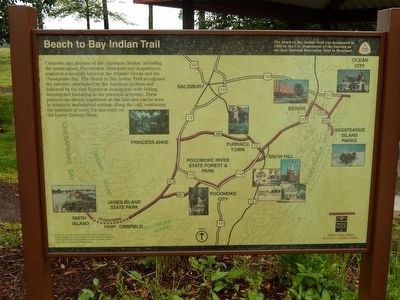
Beach to Bay Indian Trail
Centuries ago, Indians of the Algonquin Nation, including the Assateagues, Pocomokes, Manokins and Acquintacas, migrated seasonally between the Atlantic Ocean and the Chesapeake Bay. The Beach to Bay Indian Trail recognizes the patterns established by the American Indians and followed by the first European immigrants with fishing, farming and timbering as the principal activities. These patterns are deeply imprinted on the land and can be seen in relatively undisturbed settings along the trail, continuing the tradition of travel for discovery on the Lower Eastern Shore.
Erected by U.S, Department of the Interior.
Topics. This historical marker is listed in this topic list: Native Americans.
Location. 38° 0.287′ N, 75° 32.607′ W. Marker is near Pocomoke City, Maryland, in Worcester County. Marker can be reached from U.S. 13, in the median. Marker is at the Maryland Welcome Center. Touch for map. Marker is in this post office area: Pocomoke City MD 21851, United States of America. Touch for directions.
Other nearby markers. At least 8 other markers are within 5 miles of this marker, measured as the crow flies. Cultural Treasures (here, next to this marker); Wicomico Treasures (here, next to this marker); Boundary Line (here, next to this marker); Maryland's Eastern Shore (a few steps from this marker); Mark O. Pilchard (within shouting distance of this marker); Pocomoke City Historic Railroad Station (approx. 4.6 miles away); Costen House (approx. 5 miles away); In Memory of the Deceased Who Served to Protect Our Country (approx. 5.1 miles away). Touch for a list and map of all markers in Pocomoke City.
Credits. This page was last revised on June 16, 2016. It was originally submitted on May 6, 2016, by Bill Pfingsten of Bel Air, Maryland. This page has been viewed 294 times since then and 8 times this year. Photo 1. submitted on May 6, 2016, by Bill Pfingsten of Bel Air, Maryland.
