2 entries match your criteria.
Related Historical Markers
To better understand the relationship, study each marker in the order shown.
By Cajun Scrambler, June 17, 2005
The Old Saint Gabriel Church Marker
SHOWN IN SOURCE-SPECIFIED ORDER
| Near State Highway 75, 0.2 miles south of State Highway 74, on the left when traveling south. |
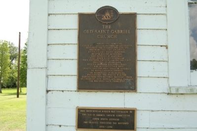
| | In 1699 Pierre Lemoyne, Sieur D'Iberville, father of Louisiana, explored the Mississippi and its distributary the Ascantia, later called Bayou Manchac. By 1758 exiled Acadians had settled at Manchac. They soon built upstream this cypress church, . . . — — Map (db m127915) HM |
| On Highway 75, 0.3 miles south of Highway 74. |
| | Co. B - Meriam's Reg't. Louisiana Militia War of 1812 Born - Jan. 9, 1770, St. Servan, France Died - Mar. 14, 1843, Iberville Parish, Louisiana Buried - Old St. Gabriel Church Cemetery St. Gabriel, Louisiana Migrated to Iberville Parish in 1785 . . . — — Map (db m108798) HM |
Jun. 16, 2024