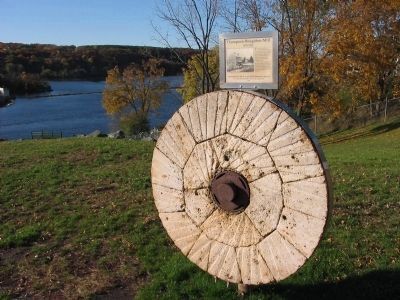
Near North Washington Street (State Highway 87) north of River Street, on the left when traveling north.
This millstone is the last remnant of the flour mill that operated on the river bank a half-mile to the south. Power was provided by the stream that now tumbles down a rocky slope on the north boundary of the Wisconsin Interstate Park.
Pieces . . . — — Map (db m216749) HM
On State Highway 35 0.4 miles south of 1st Avenue (State Highway 48), on the right when traveling south.
On March 28, 1885 one of Wisconsin's first incorporated creameries was organized as the Luck Creamery Company. The "Organization Artikler" were published in Danish in the Polk County Press on November 18, 1885, and printed in English about a month . . . — — Map (db m14576) HM
On Depot Road 0.2 miles west of South Cascade Street (Wisconsin Highway 35), on the right when traveling west.
For thousands of years, this limestone bluff has been an area landmark. Chippewa Indians camped here along the "ginseng trail" that stretched from Balsam Lake in Polk County to New Richmond in St. Croix County. Overlooking the St. Croix National . . . — — Map (db m17667) HM
Near North Cascade Street (State Highway 35) north of Osceola Road (State Highway 243), on the left when traveling north.
By 1845, the first sawmill was erected in Osceola. It stood two stories high and was capable of cutting 10,000 board feet every 24 hours. Approximately 35 million board feet were cut during its existence. It was located on Osceola Creek near the . . . — — Map (db m17554) HM
Thin black lines indicate changes in relevance. Between each pair of lines entries are ordered geographically but all have the same relevance.
* Inflectional forms of words are their plurals, singulars, and possessives as well as gramatical tenses and similar variations.