This building stands on the site of the Old Cornmarket and combined the structures of two houses to form The Winchester Provident Dispensary, set up in 1875 by a group of local citizens to provide medical help for the families of insured people . . . — — Map (db m230005) HM
Drove the Danish invaders from Wessex. He created fortified centres, of which Winchester, the largest, was his capital. During his reign, the streets in use today were first established. Alfred was the most esteemed of English kings. He . . . — — Map (db m230054) HM
The east hall was the public audience chamber of Henry of Blois, designed for large assemblies and ceremonial occasions.
The hall was probably built by 1138, when the Winchester Annals record that 'Bishop Henry built a house like a palace'. . . . — — Map (db m246537) HM
The Chesil Rectory is Winchester's oldest commercial property & one of the city's best preserved Medieval buildings.
Built by a wealthy merchant between 1425-1450, the building has been an antique shop, a tannery, a private dwelling, general . . . — — Map (db m229955) HM
The earliest reference to the City Cross is in the early 14th century, when the tenant of this building was known as Walter at the Cross. Known locally as the Butter Cross, the structure was a focal point for civic ceremonies in the later Middle . . . — — Map (db m230012) HM
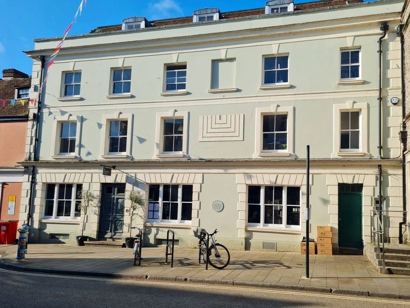
This building stands in an area known since the 11th century as Godbegeaton or 'good bargain'.
In the middle of the 15th century the present building, which forms part of a group of linked dwellings, was erected on this site. It was owned by . . . — — Map (db m230010) HM
In pre-historic times, the Itchen flowed in two main channels in the centre of the river valley, near the Cathedral. Following the foundation of the Roman town, about 70 AD, this new artificial channel was created. This both reduced the chance of . . . — — Map (db m230027) HM
There has been a mill on this site since the 12th century. The medieval mill took its name from Segrim's Fount, a stream diverted in 1360 to increase power. Segrim's was the City's principal grain mill. The existing structure was built in 1885 at . . . — — Map (db m230003) HM
On Jewry Street at St Georges Street, on the right when traveling north on Jewry Street.
This trough is a memorial to all the horses killed in the South African War 1899-1902. It was presented to the City of Winchester by Mrs Isabella Clowes who lived here for 69 years. — — Map (db m239687) WM
During the reign of King Stephen, there was a civil war - both Stephen and the Empress Matilda were claiming the English throne. As Stephen's brother and advisor, Bishop Henry was close to the centre of these affairs.
In 1141, King Stephen . . . — — Map (db m246539) HM
The surviving ruins of Wolvesey were largely the creation of one man, Bishop Henry of Blois (1129-71), who built a palace befitting his immense wealth and powerful position.
When Henry of Blois became bishop of Winchester in 1129,
the . . . — — Map (db m246448) HM
On College Street, on the left when traveling east.
You are standing at the entrance to one of the greatest medieval buildings in England - the palace of the powerful and wealthy bishops of Winchester.
Throughout the medieval period the bishops of Winchester held one of the highest positions . . . — — Map (db m246446) HM
Here stood William the Conqueror's palace. Some Norman stones have been re-used in the old chimney breast to the left of this plate.
The site was later occupied until 1409 by the City Guildhall. — — Map (db m230059) HM
The William Walker sits under the shadow of the 11th Century cathedral in the centre of Winchester. William Walker, himself a deep sea diver, was called in during the early 1900's as huge cracks started to appear in the cathedral walls.
Walker . . . — — Map (db m240340) HM
On St. Thomas Street at High Street, on the left when traveling south on St. Thomas Street.
The Guildhall was located on this site from 1361 until construction of the Victorian replacement in the Broadway. The existing building dates from 1713 and is adorned by a statue of Queen Anne and the Town Clock - gifts of rival families and . . . — — Map (db m230490) HM