Marker Logo HMdb.org THE HISTORICAL
MARKER DATABASE
“Bite-Size Bits of Local, National, and Global History”


5 entries match your criteria.  


Related Historical Markers

Battle of Rowlesburg by Markers
 
Map of Battle Area image, Touch for more information
By Craig Swain, July 24, 2010
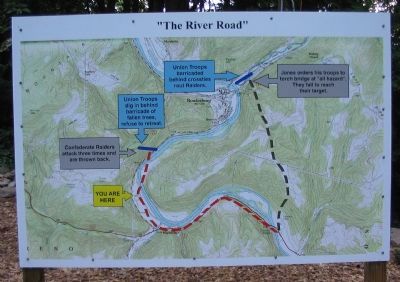
Map of Battle Area
SHOWN IN SOURCE-SPECIFIED ORDER
1 West Virginia, Preston County, Rowlesburg — Battle of Rowlesburg: "The River Road"
On River Road (State Highway 72) 0.6 miles north of Northwestern Turnpike (U.S. 50), on the right when traveling north.
2 West Virginia, Preston County, Rowlesburg — Battle of RowlesburgApril 26, 1863
On East Main Street at North Diamond Street, on the right when traveling west on East Main Street.
3 West Virginia, Preston County, Rowlesburg — The 1841 Mountain Howitzer, thought to be the type used in Rowlesburg during the Civil War
On East Main Street at North Diamond Street, on the right when traveling west on East Main Street.
4 West Virginia, Preston County, Rowlesburg — Cannon Hill
On Catherine Street (State Highway 72) at Buffalo Street, on the right when traveling west on Catherine Street.
5 West Virginia, Preston County, Rowlesburg — B&O Viaducts
On State Highway 72, on the right when traveling south.


CeraNet Cloud Computing sponsors the Historical Marker Database.
This website earns income from purchases you make after using our links to Amazon.com. We appreciate your support.
Paid Advertisement
Jun. 16, 2024