2 entries match your criteria.
Related Historical Markers
By Duane Hall, August 5, 2015
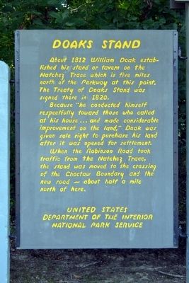
Doaks Stand
SHOWN IN SOURCE-SPECIFIED ORDER
| 1 ► Mississippi, Madison County, Canton — Choctaw Boundary — |
| On Natchez Trace Parkway (at milepost 128.4), 6.6 miles south of Mississippi Highway 16, on the left when traveling north. | |||
| 2 ► Mississippi, Noxubee County, Macon — Dancing Rabbit Creek — |
| On Jefferson Street (State Highway 145) 0.2 miles south of South Street, on the right when traveling south. | |||