6 entries match your criteria.
Related Historical Markers
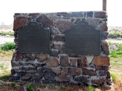
Markers located at and near Captain Jack's Stronghold in California.
By Syd Whittle, May 10, 2008
Captain Jack's Stronghold Marker
SHOWN IN SOURCE-SPECIFIED ORDER
| | From this fortress Captain Jack and his Indian forces successfully resisted capture by U.S. Army troops from December 1, 1872 to April 18, 1873. Other nearby landmarks of the Modoc Indian War are Canby's Cross, No.110 and Guillam's Graveyard, No.13 — — Map (db m154347) HM |
| | “Peaceable if you can, forcibly if you must,” ordered Indian Agent T. B. Odeneal. The U.S. Army garrison’s task was to bring the Modocs and their leader, Captain Jack, back to the reservation. His refusal started the Modoc War in the . . . — — Map (db m63213) WM |
| | Thousands of years ago, flowing lava cooled forming a natural fortress. The surrounding area later became the center of the Modoc Indian homeland. A series of events made this lava stronghold a focal point in the war to remove the Modoc from their . . . — — Map (db m87917) HM |
| |
By April 1873, months of peace talks to end the Modoc War had gone nowhere. General E.R.S. Canby found himself caught between President Grant’s Indian Peace Policy and the desire of some settlers to have the Army eliminate the Modoc band. The . . . — — Map (db m63211) WM |
| | This was the shoreline of Tule Lake in 1872-73. The Modoc Indians occupying the Stronghold obtained water at this point.
Once nearly 100,000 acres, the lake was drained between 1912 and 1958 to make fertile land available for homesteads. — — Map (db m87914) HM |
| | General E.R.S. Canby was murdered here in April, 1873, while holding a peace parley under flag of truce with Captain Jack and Indian Chiefs. Rev. Eleazer Thomas, Peace Commissioner, was likewise treacherously slain. — — Map (db m154348) HM |
Apr. 26, 2024