5 entries match your criteria.
Related Historical Markers
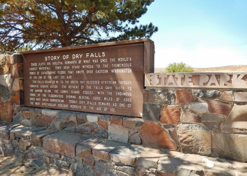
Sun Lakes-Dry Falls State Park
By Cosmos Mariner, July 31, 2015
Story of Dry Falls Marker (wide view)
SHOWN IN SOURCE-SPECIFIED ORDER
| | These cliffs are skeletal remnants of what was once the world’s largest waterfall. They bear stark witness to the tremendous power of catastrophic floods that swept over Eastern Washington at the end of the last Ice Age.
The falls began 20 mi. to . . . — — Map (db m129677) HM |
| | Flood waters, perhaps 300 feet above you, once rushed over these cliffs. During the ice age, glaciers to the north blocked the Columbia River and forced it to find a new route. The river, swollen from melting glacial ice, began to carve a new . . . — — Map (db m129678) HM |
| | The sheer cliff in front of you was once the world's greatest waterfall. From here, you see only the western portion of this remarkable Ice Age floods feature. With the end of the last Ice Age, floodwaters no longer swept through Grand Coulee, . . . — — Map (db m129679) HM |
| | You are standing in the pathway of some of the largest floods ever known. They carved steep-walled canyons, sculpted immense waterfalls, and left behind landscapes found nowhere else on earth.
Massive Glacial Dams and Lakes During the last . . . — — Map (db m129680) HM |
| | Raging Ice Age floodwaters carved spectacular features throughout eastern Washington, creating unique landscapes. Follow the path of the floods and discover more about this amazing story.
Gouging Deep Coulees The powerful floods cut . . . — — Map (db m129681) HM |
May. 4, 2024