2 entries match your criteria.
Related Historical Markers
Old Marker At This Location titled "It is A.P. Hill" and New Markers At This Location titled "The Fate of the Army".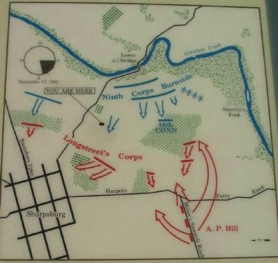
By Craig Swain, February 9, 2008
Battle Map
SHOWN IN SOURCE-SPECIFIED ORDER
| 1 ► Maryland, Washington County, Sharpsburg — “It Is A.P. Hill” — |
| Outnumbered Southerners watched the Northern Ninth Corps climb the hills toward them: "The first thing we saw was the gilt eagle that surmounted the pole, then the top of the flag, next the flutter of the stars and stripes itself, slowly . . . — — Map (db m6520) HM | |||
| 2 ► Maryland, Washington County, Sharpsburg — The Fate of the Army — Antietam National Battlefield — |
| (1) After defending the Lower (Burnside) Bridge, the Confederates fell back to this ridge and then to the high ground west of this point. When the final Union attack started, there were more than 2,000 Confederate soldiers and more than forty cannon . . . — — Map (db m185651) HM | |||