Nauvoo in Hancock County, Illinois — The American Midwest (Great Lakes)
Historic Nauvoo

Photographed by Bill Kirchner, April 19, 2012
1. Historic Nauvoo Marker
In 1839 the Mormons, or Latter Day Saints, settled at Nauvoo and made it their chief city. During their residence its population reached 15,000. After long friction with non-Mormons the Mormons were expelled in 1846. Three years later French communists called Icarians established a society here which lasted until 1857.
Erected 1936 by the State of Illinois. (Marker Number 1.)
Topics and series. This historical marker is listed in these topic lists: Religion & Religious Structures • Settlements & Settlers. In addition, it is included in the Illinois State Historical Society series list. A significant historical year for this entry is 1839.
Location. 40° 33.062′ N, 91° 21.83′ W. Marker is in Nauvoo, Illinois, in Hancock County. It is on North Horton Street (Illinois Route 96) south of Young Street, on the right when traveling west. Touch for map. Marker is in this post office area: Nauvoo IL 62354, United States of America. Touch for directions.

Regionally, this marker is in Central Illinois. It is also in the American Midwest, in the Corn Belt, and in the Great River Road Region. Globally, it is in North
this page online
Other nearby markers. At least 8 other markers are within 2 miles of this marker, measured as the crow flies: Commerce on the River (approx. one mile away); Nauvoo (approx. one mile away); The Prophet's Last Ride (approx. 1.1 miles away); West Grove (approx. 1.2 miles away); Edward & Anne Hunter Home (approx. 1.2 miles away); William and Elizabeth Jones Property (approx. 1.2 miles away); The Icarian Community in Nauvoo (approx. 1.2 miles away); William & Caroline Weeks Home (approx. 1.2 miles away). Touch for a list and map of all markers in Nauvoo.
Related marker. Click here for another marker that is related to this marker. An identical marker stands south of town.
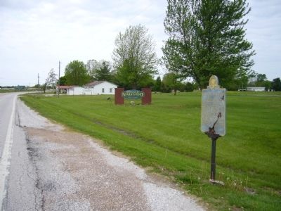
Photographed by Bill Kirchner, April 19, 2012
2. Historic Nauvoo Marker
View west on IL-96.
Credits. This page was last revised on November 8, 2026. It was originally submitted on May 17, 2012, by Bill Kirchner of Tucson, Arizona. This page has been viewed 656 times since then and 59 times this year. Last updated on November 8, 2026, by Matthew Stevens of Washington, Illinois. Photos: 1, 2. submitted on May 17, 2012, by Bill Kirchner of Tucson, Arizona. • Devry Becker Jones was the editor who published this page.
