2 entries match your criteria.
Related Historical Markers
By Duane Hall, August 5, 2015
Doaks Stand
SHOWN IN SOURCE-SPECIFIED ORDER
| 1 ► Mississippi, Madison County, Canton — Choctaw Boundary — |
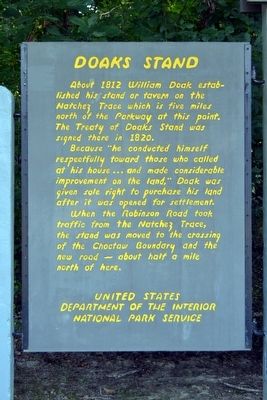
| (Left Panel) Doaks Stand About 1812 William Doak established his stand or tavern on the Natchez Trace which is five miles north of the Parkway at this point. The Treaty of Doaks Stand was signed there in 1820. Because . . . — — Map (db m87493) HM | |||
| 2 ► Mississippi, Noxubee County, Macon — Dancing Rabbit Creek — |
| West 15 miles is the site which gave name to last treaty with the Choctaws, Sept. 7, 1830, whereby the remaining tribal lands in the state were opened to white settlement. — — Map (db m92655) HM | |||