3 entries match your criteria.
Related Historical Markers
The Peshtigo Fire
By I, Royalbroil plus Ruhrfisch via Wikimedia Commons
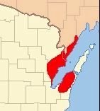
Extent of the Peshtigo Fire
SHOWN IN SOURCE-SPECIFIED ORDER
| On Oconto Avenue (County Highway B) west of Ellis Avenue, on the right when traveling west. |
| | On the night of 0ctober 8, 1871, Peshtigo, a booming town of 1700 people, was wiped out of existence in the greatest forest fire disaster in American history.
Loss of life and even property in the great fire occurring the same night in Chicago . . . — — Map (db m120657) HM |
| On French Street (Business U.S. 41) east of West Front Street, on the left when traveling east. |
| |
This bridge crosses the river that has been the heart of the
community since the founding of Peshtigo.
This river provides power for our commerce and daily lives.
This river also protected some of our citizens who sought
refuge in . . . — — Map (db m120500) HM |
| On Maple Street (U.S. 41) at East Front Street (County Highway B) on Maple Street. |
| | To the memory of over 600 men, women and children who perished when every building in the Village of Peshtigo was burned and many surrounding farms were devasted in the great tornado of fire October 8, 1871. — — Map (db m120658) HM |
May. 21, 2024