4 entries match your criteria.
Related Historical Markers
Fort Leavenworth - Fort Riley Military Road
By William Fischer, Jr., May 17, 2012
Ft. Leavenworth - Ft. Riley Military Road Marker
SHOWN IN SOURCE-SPECIFIED ORDER
| On Poyntz Avenue at 12th Street, on the right when traveling west on Poyntz Avenue. |
| |
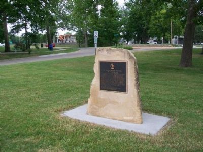
After crossing the Blue River and entering Riley County at the foot of Poyntz Avenue, "The Great Military Road" proceeded west to this point, where it angled off southwest passing through Theodore Roosevelt School grounds, Longs Park, and . . . — — Map (db m122967) HM |
| On East Bertrand Avenue (U.S. 24) at Grand Avenue, on the right when traveling east on East Bertrand Avenue. |
| | The “Great Military Road” from Fort Leavenworth to Fort Riley, as well as the Oregon Trail, passed through Saint Mary's in the 1850's. Military traffic, emigrants on their way West, settlers, and stage coach lines also used this route. Stage . . . — — Map (db m122964) HM |
| On Poyntz Avenue at 12th Street, on the right when traveling west on Poyntz Avenue. |
| |
After crossing the Blue River and entering Riley County at the foot of Poyntz Avenue, "The Great Military Road" proceeded west to this point, where it angled off southwest passing through Theodore Roosevelt School grounds, Longs Park, and . . . — — Map (db m122967) HM |
| On Railroad Street (U.S. 24) east of Shawnee Street, on the right when traveling east. |
| | The Fort Riley Trail (northern route) passed by this spot beginning in 1853 when the Fort was established. The trail came from Fort Leavenworth. Mounted and foot soldiers used this northern route because the river valley silt and sand would not . . . — — Map (db m122969) HM |
May. 8, 2024