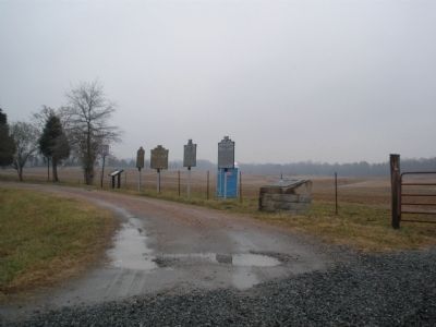
On Meadow Road, 0.1 miles east of Grapevine Road, on the right when traveling east. Reported missing.
Here, facing west, stretched the Union line in the afternoon of June 29, 1862. Brook's brigade was south of the road with Gorman's and Burn's brigades to the north. In a furious conflict Burn's line was broken but was restored by Sumner in person. . . . — — Map (db m196719) HM
On Meadow Road (County Route 156), on the right when traveling east. Reported missing.
Here Magruder’s line of Battle, facing east, formed in the late afternoon of June 29, 1862. Barksdale’s, Semmes’s and Kershaw’s Brigades, extending from south of this road to the railroad, made a desperate effort to prevent the Union withdrawal. . . . — — Map (db m196721) HM
On Meadow Road (County Route 156), on the right when traveling east. Reported missing.
In this vicinity a part of McClellan’s army remained for several weeks after the Battle of Seven Pines. The part of his army north of the Chickahominy was attacked by Lee, June 26-27, 1862. McClellan then began to withdraw to the James, June 28-29, . . . — — Map (db m196720) HM
On Meadow Road (County Route 156), on the right when traveling east.
After crossing the Chickahominy River to the north at Grapevine Bridge, portions of Maj. Gen. George B. McClellan’s retreating Union army destroyed the bridge and moved southeast along this road on 28 June 1862. After rebuilding the bridge the next . . . — — Map (db m8134) HM
On Meadow Road, 0.1 miles east of Grapevine Road, on the right when traveling east.
In the field beyond this marker was fought June 29, 1862, the battle of Savage Station in which Confederate forces under command of Major-General John B. Magruder attacked indecisively the rearguard of the Federal Army moving toward James River. . . . — — Map (db m14209) HM
On Meadow Road (County Route 156), on the right when traveling east.
On the night of June 27, 1862, following the Battle of Gaines’ Mill, Gen. George McClellan ordered a withdrawal of his Union army to the James River. In the wake of the retreating army, Savage’s Station, located one half mile in front of you along . . . — — Map (db m3685) HM
On Meadow Road (County Route 156), on the right when traveling east. Reported missing.
In this vicinity a part of McClellan’s army remained for several weeks after the Battle of Seven Pines. The part of his army north of the Chickahominy was attacked by Lee, June 26-27, 1862. McClellan then began to withdraw to the James, June 28-29, . . . — — Map (db m196720) HM
On East Williamsburg Road (U.S. 60) 0.1 miles west of Drybridge Road, on the right when traveling west.
On 26 June 1862, Maj. Gen. George B. McClellan abandoned his plan to besiege Richmond and began his retreat to the James River. Gen. Robert E. Lee pursued, determined to destroy the Army of the Potomac. Just north of here at Allen's Farm, at 9:00 . . . — — Map (db m15682) HM
On E Nine Mile Road (Virginia Route 33), on the left when traveling west.
This intersection of the Richmond and York River Railroad with the Nine Mile Road became one of Henrico County’s best-known landmarks during the Civil War. Fair Oaks Station lay on the north side of the junction. As part of Gen. Joseph E. Johnston’s . . . — — Map (db m10604) HM
On East Williamsburg Road (U.S. 60) 0.1 miles east of Interstate 295, on the right when traveling east.
On 25 June 1862 began the Seven Days' Battles as Gen. Robert E. Lee engaged Maj. Gen. George B. McClellan's Army of the Potomac, prompting McClellan to withdraw to the James River. Just north of here at 9:00 A.M. on 29 June, Brig. Gen. John B. . . . — — Map (db m15666) HM