4 entries match your criteria.
Related Historical Markers
Markers found at the Endview Plantation.
By Bill Coughlin, August 11, 2008
Marker at Endview Plantation
SHOWN IN SOURCE-SPECIFIED ORDER
| On Yorktown Road (Virginia Route 238), on the right when traveling north. |
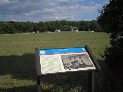
| | The white two-and-a-half story frame building in front of you in the distance is Endview. Endview was built circa 1760 by Col. William Harwood, Jr., who was a member of the House of Burgesses, a signer of the Virginia Resolves, and a Warwick County . . . — — Map (db m181356) HM |
| Near Yorktown Road (Virginia Route 238), on the right when traveling north. |
| | The fresh water bubbling from this natural spring has supported wildlife and the various residents on this property: Indian hunting parties, the Harwood/Curtis families, and military encampments. During the American Revolution, General George . . . — — Map (db m16563) HM |
| Near Yorktown Road (Virginia Route 238), on the right when traveling north. |
| | Located near a circa 1630 house site, this graveyard has held the mortal remains of the Harwood family and other persons since the seventeenth century. Southern plantations typically had a private plot containing the graves of several generations of . . . — — Map (db m16564) HM |
| Near Yorktown Road (Virginia Route 238), on the right when traveling north. Reported permanently removed. |
| | In the South, dairy buildings were small structures, usually 14 feet square with a gable roof. The buildings’ overhanging eaves, louvered ventilators, and insulated walls were designed to keep the milk cool inside. Milk was placed in shallow tubs . . . — — Map (db m185288) HM |
May. 4, 2024