Choices
What route would you take?
— Scotts Bluff National Monument —
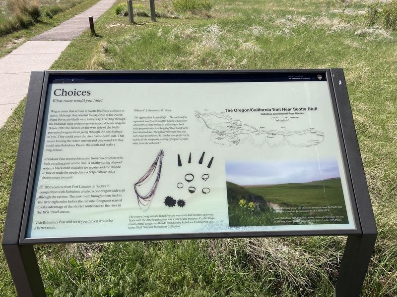
Wagon trains that arrived at Scotts Bluff had a choice to make. Although they wanted to stay close to the North Platte River, the bluffs were in the way. Traveling through the badlands next to the river was impossible for wagons. Before 1851 the ravines on the west side of the bluffs prevented wagons from going through the notch ahead of you. They could cross the river to the north side. That meant braving the water current and quicksand. Or they could take Robidoux Pass to the south and make a long detour.
Robidoux Pass received its name from two brothers who built a trading post on the trail. A nearby spring of good water; a blacksmith available for repairs and the chance to buy or trade for needed items helped make this a decent route to travel.
In 1850 soldiers from Fort Laramie or traders in competition with Robidoux created a one-wagon wide trail through the ravines. The new route brought them back to the river eight miles before the old one. Emigrants started to take advantage of the shorter route back to the river in the 1851 travel season.
Visit Robidoux Pass and see if you think it would be a better route.
William C. Lobenstine; 1851 diaryThe covered wagon trade lasted for only one and a half months each year. Trade with the American Indians was a year round business.
"We approached Scotch Bluffs … The rock itself is separated nearly at its middle, having a pass here about fifty to sixty feet wide, ascending at both sides perpendicular to a height of three hundred to four hundred feet. The passage through here was only made possible in 1851 and is now preferred by nearly all the emigrants, cutting off a piece of eight miles from the old road."
[Captions:]
The map shows the choice of routes around the bluffs that the wagon trains had beginning in 1851.
Robidoux Pass as it looks today. Although the route was out of the way, it was gentler than Mitchell Pass.
Erected by National Park Service, U.S. Department of the Interior.
Topics. This historical marker is listed in these topic lists: Roads & Vehicles • Settlements & Settlers. A significant historical year for this entry is 1850.
Location. 41° 49.716′ N, 103° 42.492′ W. Marker is near Gering, Nebraska, in Scotts Bluff County. Marker is on Old Oregon Trail (County Road K) 1˝ miles west of Meadowlark Road, on the right when traveling west. Touch for map. Marker is at or near this postal address: 190276 Old Oregon Trail, Gering NE 69341, United States of America. Touch for directions.
Other nearby markers. At least 8 other markers are within walking distance of this marker. Scott's Bluff Pony Express Station (about 300 feet away, measured in a direct line); A Transportation Corridor
Related marker. Click here for another marker that is related to this marker. This marker has replaced the linked marker.
Credits. This page was last revised on June 4, 2021. It was originally submitted on May 30, 2021, by Connor Olson of Kewaskum, Wisconsin. This page has been viewed 127 times since then and 7 times this year. Photos: 1, 2. submitted on May 30, 2021, by Connor Olson of Kewaskum, Wisconsin. • Devry Becker Jones was the editor who published this page.

